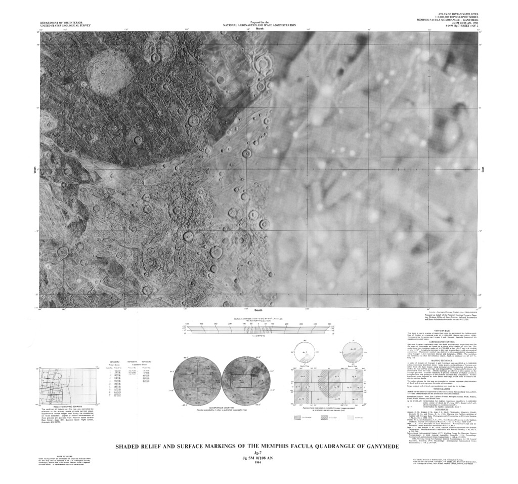
Ganymede Shaded Relief and Surface Markings of the Memphis Facula Quadrangle
- Publisher
- USGS Astrogeology Science Center
- Abstract
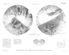
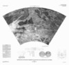
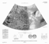
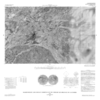
- NOTES ON BASE: This sheet is one in a series of maps that covers the surface of Galilean satellites of Jupiter at a nominal scale of 1: 5,000,000 (Batson and others, 1980). Sources for the series were Voyager 1 and 2 images and 1:5,000,000-scale airbrush maps. Essential features of the mapping are noted below. CARTOGRAPHIC CONTROL: Mercator, Lambert Conformal Conic, and Polar Stereographic projections used for the maps of Ganymede are based on a sphere with a radius of 2638 km. The projections have a common scale of 1: 4,780,000 at lat ±21.3Ë and 1:4,769,000 at lat ±65.2Ë. Longitude increases to the west in accordance with the astronomical convention. Planimetric control was derived by photogrammetric triangulation using Voyager 1 and 2 pictures (Davies and Kayayama, 1981). The meridians are numbered so that the reference crater, Anat, is centered on lat 2.8ËS., long 128Ë (Davies and Kayayama, 1981; IAU, 1980a). MAPPING TECHNIQUE: A series of mosaics of Voyager 1 and 2 pictures was assembled at 1:5,000,000 scale using projections described above. Sizes, shapes and positions of features were taken from the base mosaic using portrayal and interpretation techniques described by Inge (1972) and Inge and Bridges (1976). Surface relief is shown as if illuminated from the west. Albedo markings are shown as they appear on the Voyager pictures. Extreme variations in picture resolution precluded consistent interpretation and portrayal of the pictures used for map compilation. Further limitations were imposed by dark albedo markings, which tend to obscure distinctive surface details. The colors chose for this map are intended to provide optimum discrimination of detail and do not represent the color of Ganymede. Image analysis and airbrush representation were made by Patricia Hagerty-Gray References *Batson, R.M., Bridges, P.M., Inge, J.L. Isabell, Christopher, Masursky, Harold, Strobell, M.E., and Tyner, R.L., 1980, Mapping the Galilean satellites of Jupiter with Voyager data: Photogrammetric Engineering and Remote Sensing, v. 46, n0. 10, p.1303-1312. *Davies, M.E., and Katayama, F.Y., 1981, Coordinates of features on the Galilean Satellites: Journal of Geophysical Research, v.86, no. A10, p.8635-8657. *Inge, J.L. 1972, Principles of lunar Illustration: Aeronautical Chart and Information Center Reference Publication RP-72-1, 60p. *Inge, J.L., and Bridges, P.M., 1976, Applied photointerpretation for airbrush cartography: Photogrammetric Engineering and Remote Sensing, v.42, no.6, p.749-760.
Contact and Distribution
- Format
- Shaded-Relief Map
- Access Scope
- Series Id
- 1498
- Native Data Set Environment
- Astrogeology Theme
- Cartography, Remote Sensing, Topography
- Online Package Link
- https://astrogeology.usgs.gov/search/map/ganymede_shaded_relief_and_surface_markings_of_the_memphis_facula_quadrangle
- External File Size
- 5989435
- Online File Link
- http://astropedia.astrogeology.usgs.gov/download/Ganymede/Topography/Ganymede-Shaded-Relief-and-Surface-Markings-of-the-Memphis-Facula-Quadrangle.pdf
- Access Instructions
- 2 remote-sensing images :1 col. ;40 x 65 cm., on sheets 58 x 72 cm., folded in envelope 30 x 24 cm.
- Contact Address
- 2255 N. Gemini Drive
- Contact City
- Flagstaff
- Contact State
- AZ
- Contact Postal Code
- 86001
- Contact Email
- [email protected]
Geospatial Information
- Target
- Ganymede
- System
- Jupiter
- Object Type
- Grid Cell
- Quad Name
- Map Scale (hard-copy)
- 1:5000000
- Horizontal Coordinate System Units
- Degrees