
Dione Voyager Image Control Network
- Primary Authors
- Brent Archinal
- Originators
- USGS Astrogeology Science Center
- Publisher
- USGS Astrogeology Science Center
- Publication Date
- 2025-04-01
- Abstract
-
This archive has been created as part of a project to put planetary control networks on the web. These control networks originated from the RAND corporation (Merton Davies and Tim Colvin) and were provided to Brent Archinal of the USGS in 2000. The control network solutions were originally performed with software developed at RAND and documented by Colvin (1992). The RAND software was subsequently converted into files that could be used with (successively) the RAND/USGS Planetary Geodesy (RUPG) Software, and the USGS ISIS2 "randlsq" software. In 2020, the RAND control network files were converted to the ".net" binary format, used in ISIS3 and later versions of ISIS (hereafter shown as "ISIS3+"). These were then processed via the ISIS3+ "Jigsaw" program, which had been based on randlsq and is described by Edmundson et al. 2012. Each RAND-format control network is essentially a set of photogrammetric solution (input and output) files. The input files consist of a parameter input file for specifying how the solution should be done, a priori information on control point (the measured points in common to multiple images, sometimes called tie points) locations and spacecraft position and pointing information, and pixel location measurements of the control points on images of a planetary body. The output files include the body coordinates of the control points in latitude, longitude, and radius, revised orientation information (camera pointing) for the images, and (optionally) updated information on the size and orientation of the body. The binary ISIS3+ ".net" format contains all network data in a single file. The primary use of such information is for the creation of image mosaics of the planetary body. However, as just noted, these solutions can also provide fundamental data on the size and shape of the body, its spin orientation and rate, and the direction of its polar axis in space. The control point coordinates also usually serve as a coordinate reference frame that can be used to define the fundamental coordinate reference system for the body in question. Formatting of these control network data has been updated for compatibility with the USGS ISIS2 and ISIS3+ planetary imaging and cartography software. These networks were generated using images from the Voyager 2 mission (Davies et al., 1987). This release comprises data from original RAND control network solutions, the ISIS2 "matchpoint" formatted control networks, and RAND and USGS (jigsaw-processed) solutions to the control networks in ISIS3+ format.
Edmundson, K. L. ; Cook, D. A. ; Thomas, O. H. ; Archinal, B. A. ; Kirk, R. L., 2012, Jigsaw: the ISIS3 Bundle Adjustment for Extraterrestrial Photogrammetry, ISPRS Annals of the Photogrammetry, Remote Sensing and Spatial Information Sciences, Volume I-4, 2012, pp.203-208.Image Description:
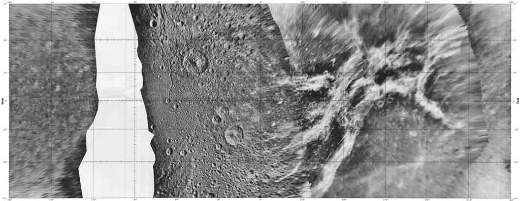
This image is a USGS controlled photomosaic of Dione, compiled from Voyager 1 and 2 images. We believe this 1992 image was created either form the RAND control network provided here, or from an updated version of the same network. - Purpose
- Created as part of a project to put planetary geodesy control networks on the web. The Dione Voyager control network data here was originally provided by Merton Davies and Tim Colvin of the RAND Corporation. Funds were provided for a conversion and archiving effort by the NASA Planetary Geology and Geophysics Program and the NASA Cartography Program.
Contact and Distribution
- Format
- Control Network
- Native Data Set Environment
- ISIS v3
- Astrogeology Theme
- Control Network
- Mission Names
- Voyager
- Instrument Names
- ISS
- Online Package Link
- https://astrogeology.usgs.gov/search/map/dione_voyager_image_control_network
- External File Size
- 12 MB
- Online File Link
- https://10.12.88.65/ckan/dataset/0b45488a-f815-47bd-9b6d-8b9651d1d685/resource/a3793255-7ce0-4c28-b161-df2e6581dd58/download/saturn_voyager_controlnetworks_usgs_2025.zip
- Access Instructions
-
Contained in this archive are the necessary data to open the RAND solution of the Dione control network in ISIS3 programs, in the ISIS2 qmatch format (.mat) and in its original RAND solution format.
Dione Control Network files:
ISIS3 Control Networks:
dione_rand_isis3.net RAND solution measurements in ISIS3 format. Converted to ISIS3 by the routine mat2cnet.
dione_usgs_isis3_jig.net USGS solution measurements in ISIS3 format. This the RAND solution after processing through the Jigsaw bundle-adjustment program.
Control Network in previous formats:
di-inp.dat RAND solution poles, points, and positions a priori input file.
di-mea.dat RAND solution image measurements (mm) input file.
di-par.dat RAND solution program operation control input file.
Dione_matchpoint_network.mat RAND solution provided as a USGS Matchpoint file.
- Contact Address
- 2255 N. Gemini Drive
- Contact City
- Flagstaff
- Contact State
- AZ
- Contact Postal Code
- 86001
- Contact Email
- [email protected]
- Completeness Report
-
This is a global control network of Dione, and incorporates most of the usable images from the Voyager I and II missions.
- Process Description
-
RAND solution files from the 1980s are provided as *.dat files. The conversion to ISIS2 match point format (.mat) was performed in 2003 without making corrections or adjustments to the network. Conversion to ISIS3+ format (.net) was performed in 2022 without making corrections or adjustments to the network. The ISIS3+ network was processed through the USGS 'Jigsaw' bundle-adjustment program; no tests have been performed to ensure the accuracy of this network, but Jigsaw output statistics are provided in this release.
- Source Title
- The control networks of Tethys and Dione
- Source Online Linkage
- http://onlinelibrary.wiley.com/doi/10.1029/JA088iA11p08729/abstract
Geospatial Information
- Target
- Dione
- System
- Saturn
- Direct Spatial Reference Method
- Point
- Object Type
- Point
- Horizontal Coordinate System Units
- Degrees
- Vertical Coordinate System Units
- Meters


