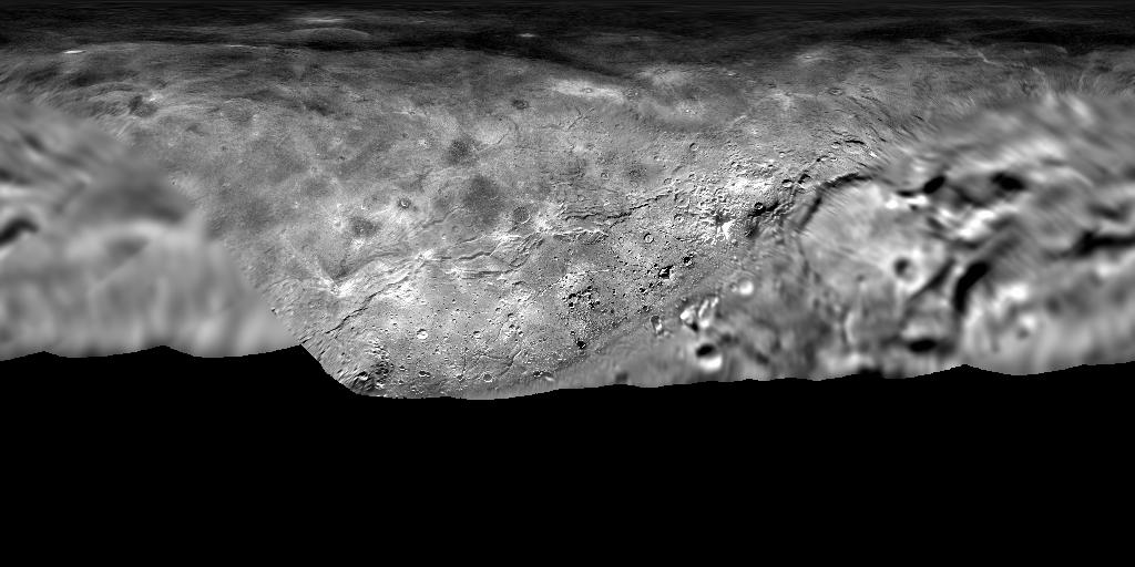
Charon New Horizons LORRI MVIC Global Mosaic 300m
- Primary Authors
- New Horizons Team
- Originators
- NASA, Johns Hopkins University Applied Physics Laboratory, Southwest Research Institute, Lunar and Planetary Institute
- Publisher
- USGS Astrogeology Science Center
- Publication Date
- 2017-07-14
- Abstract
- Product Information: This detailed, high-quality global mosaic of Pluto's largest moon, Charon, was assembled from nearly all of the highest-resolution images obtained by the Long-Range Reconnaissance Imager (LORRI) and the Multispectral Visible Imaging Camera (MVIC) on New Horizons. The mosaic is the most detailed and comprehensive global view yet of Charon's surface using New Horizons data. Standing out on Charon is an enormous trough at least 350 kilometers long, and reaching 14 kilometers deep, more than seven times as deep as the Grand Canyon. This mosaic is available in equirectangular projection at an equatorial pixel scale of 300 meters per pixel (m). An ISIS3 cube 32bit formatted file is available from the ancillary section. This map was produced using radii of 606 kilometers for Charon. Mission and Instrument Information: Pluto was discovered on February 18, 1930 at Lowell Observatory in Flagstaff, Arizona. It was discovered by an observing assistant, Clyde Tombaugh, as he assisted the search for planet X which was believed (incorrectly) to be responsible for anomalies in the orbits of Uranus and Neptune. At about half the size of Earth's moon, Pluto has been officially re-classified as a dwarf planet. It is in the Kuiper Belt and orbits the sun at an average distance of 3.6 billion miles. Pluto has five moons, the largest of which is Charon. Pluto and Charon orbit each other like a double planet system. New Horizons spacecraft launched onboard a Lockheed Martin Atlas V rocket at Cape Canaveral Air Force Station in Florida on January 19, 2006. The main objectives of New Horizons was a Pluto Flyby and a Kuiper Belt Object Flyby. The science payload includes seven instruments: visible and infrared imager/spectrometer (Ralph), ultraviolet imaging spectrometer (Alice), Radio science EXperiment (REX), Long Range Reconnaissance Image (LORRI), solar wind around Pluto (SWAP), Pluto Energetic Particle Spectrometer Science Investigation (PEPSSI), and Student Dust Counter (SDC). New Horizons passed Mars on April 7th, 2006 and received a gravity assist from Jupiter on Feb 28th, 2007. The spacecraft was put into hibernation mode starting June 28th, 2007 and it reached the halfway point to Pluto on February 25th, 2010. Ground controllers revived New Horizons from hibernation on December 6th, 2014. At that time, it took four hours and twenty-five minutes for a signal from the spacecraft to reach Earth. New Horizons began its approach to Pluto on January 15th, 2015 and flew about 4,800 miles above the surface of Pluto on July 14th, 2015. The entire series of data collected during New Horizons' encounter with Pluto and Charon is about 6.25 gigabytes and was transmitted to earth at about 1-2 kilobits per second over a distance of roughly 4.5 light-hours from Earth. As of March 2019, New Horizons was about 4.1 billion miles from Earth and continuing its journey deep into the Kuiper Belt at nearly 33,000 miles per hour. The New Horizons mission is currently extended through 2021 with the objective to explore Kuiper Belt objects. References: Moore, J. M., McKinnon, W. B., Spencer, J. R., Howard, A. D., Schenk, P. M., Beyer, R. A., Nimmo, F., et al. (2016). The Geology of Pluto and Charon Through the Eyes of New Horizons. Science, 351(6279), 1284-1293. https://10.1126/science.aad7055 Schenk, P., Beyer, R. A., McKinnon, W. B., Moore, J. M., Spencer, J. R., White, O. L., New Horizons Geology and Geophysics Investigation Team, et al. (2018). Breaking Up is Hard to Do: Global Cartography and Topography of Charon from New Horizons. Icarus, 315, 124-145. https://doi.org/10.1016/j.icarus.2018.06.010
- Purpose
- Image map of Charon
Contact and Distribution
- Format
- Global Mosaic, Image, Remote-sensing Data
- Access Constraints
- None
- Access Scope
- PDS
- Use Constraints
- Please cite authors
- Edition
- 2016-12-12T15:42:39
- Edition Name
- Charon's Surface in Detail
- Supplemental Information
- https://arxiv.org/abs/1604.05702
- Native Data Set Environment
- ISIS v3
- Astrogeology Theme
- Image Processing, Regolith
- Mission Names
- New Horizons
- Online Package Link
- https://astrogeology.usgs.gov/search/map/charon_new_horizons_lorri_mvic_global_mosaic_300m
- External File Size
- (77 MB)
- Online File Link
- https://planetarymaps.usgs.gov/mosaic/Charon_NewHorizons_Global_Mosaic_300m_Jul2017_8bit.tif
- Contact Address
- 2255 N. Gemini Drive
- Contact City
- Flagstaff
- Contact State
- AZ
- Contact Postal Code
- 86001
- Contact Email
- astroweb@usgs.gov
Data Status and Quality
- Time Period of Content (start)
- 2015-07-14
- Time Period of Content (stop)
- 2016-10-25
- Currentness Reference
- Ground condition
- Progress
- Complete
- Update Frequency
- As needed
- Process Description
- The original 32bit pixel values were stretch to 8bit (1-255) using a 0.5% to 99.5% range which resulted in in using the pixel value range from 0.10892 to 1.3745.
- Source Title
- Charon's Surface in Detail
- Source Online Linkage
- {https://pds-smallbodies.astro.umd.edu/holdings/nh-p_psa-lorri_mvic-5-geophys-v1.0/dataset.html,https://pds-smallbodies.astro.umd.edu/data_sb/missions/newhorizons/index.shtml}
- PDS Status
- PDS 3 Archived
Geospatial Information
- Target
- Charon
- System
- Pluto
- Minimum Latitude
- -90
- Maximum Latitude
- 90
- Minimum Longitude
- 0
- Maximum Longitude
- 360
- Direct Spatial Reference Method
- Raster
- Object Type
- Grid Cell
- Raster Row Count (lines)
- 6347
- Raster Column Count (samples)
- 12693
- Bit Type (8, 16, 32)
- 8
- Quad Name
- Radius A
- 606000
- Radius C
- 606000
- Bands
- 1
- Pixel Resolution (meters/pixel)
- 300
- Scale (pixels/degree)
- 35.255650890285
- Map Projection Name
- Simple Cylindrical
- Latitude Type
- Planetographic
- Longitude Direction
- Positive East
- Longitude Domain
- 0 to 360


