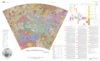

Mars Geologic Map of the MTM 25047 and 20047 Quadrangles, Central Chryse Planitia/Viking 1 Lander Site
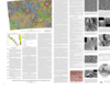
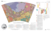
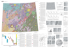
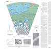
This map uses Viking Orbiter image data and Viking 1 Lander image data to evaluate the geologic history of a part of Chryse Planitia, Mars. The map area lies at the termini of the Maja and Kasei Valles outwash channels and includes the site of the Viking 1 Lander. The photomosaic base for these quadrangles was assembled from 98 Viking Orbiter frames comprising 1204 pixels per line and 1056 lines and ranging in resolution from 20 to 200 m/pixel. These orbital image data were supplemented with images of the surface as seen from the Viking 1 Lander, one of only three sites on the martian surface where planetary geologic mapping is assisted by ground truth.
- Mimetype
- application/pdf
- Filename
- Mars-Geologic-Map-of-the-MTM-25047-and-20047-Quadrangles-Central-Chryse-PlanitiaViking-1-Lander-Site.pdf
- Publisher
- USGS Astrogeology Science Center
- Publication Date
- 1 January 2001
- Originator
- L. Crumpler, R. Craddock, J. Aubele
- Group
- RPIF
- Added to Astropedia
- 3 May 2016
- Modified
- 12 April 2018
General
- Geospatial Data Presentation Form
- Geologic Map, Raster Data, Vector Data
- Series Id
- 2693
Keywords
- Target
- Mars
- Theme
- Cartography, Geology, Geomorphology, Photogeology, Stratigraphy, Planetary evolution
- Mission
- Viking
Contact and Distribution
- Access Instructions
- 1 Map: 95 x 94 cm
Geospatial Information
- Minimum Latitude
- 22
- Maximum Latitude
- 27
- Minimum Longitude
- 0
- Maximum Longitude
- 315
- Quad Name
- MC-10, MC-11, MC-12
- Map Projection Name
- Transverse Mercator