Products

567 Results Collapse
Map Projection on the Web (POW) Presentation thumbnail

Map Projection on the Web (POW) Presentation

application/pdf 3 MB

POW will provide users with calibrated cartographic images that can be used for geologic mapping, analysis in a GIS, change detection, merging of dissimilar instrument images, and use in a host of…

Mars MGS MOLA Global Color Shaded Relief 463m v1 thumbnail

Mars MGS MOLA Global Color Shaded Relief 463m v1

application/isis 3 GB

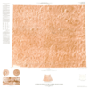
Product Information: This map is based on data from the Mars Orbiter Laser Altimeter (MOLA) (Smith, et al., 2001), an instrument on NASA’s Mars Global Surveyor (MGS) spacecraft (Albee, et al.,…

Mars MGS MOLA - MEX HRSC Blended Shaded Relief 200m v2 thumbnail

Mars MGS MOLA - MEX HRSC Blended Shaded Relief 200m v2

application/octet-stream 1 kB

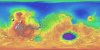
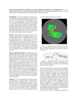
This is a shaded relief of the original DEM described next. This data product, now at version 2, is a blend of digital elevation model (DEM) data derived from the Mars Orbiter Laser Altimeter (MOLA),…

Mars Viking Lander 2 Rectified Photomosaics thumbnail

Mars Viking Lander 2 Rectified Photomosaics

application/pdf 9 MBNov 23 2023

Mars Viking Lander 1 Rectified Photomosaics thumbnail

Mars Viking Lander 1 Rectified Photomosaics

application/pdf 9 MBNov 21 2023

Mars Controlled Mosaic of the Canberra Region thumbnail

Mars Controlled Mosaic of the Canberra Region

application/pdf 6 MBOct 16 2023

Project Pages

10 Results Collapse

Documents

60 Results Collapse
ISPRS 1998 Mars MGS MOLA Global Geodetic Control Network thumbnail

ISPRS 1998 Mars MGS MOLA Global Geodetic Control Network

application/pdf 91 kB

The Mars Orbiter Laser Altimeter (MOLA) on the Mars Global Surveyor (MGS) mission will produce a precision global geodetic control network for Mars of 30,000 - 50,000 points which will be accurate to…

ISPRS 1998 Status of the RAND Control Network of Mars thumbnail

ISPRS 1998 Status of the RAND Control Network of Mars

application/pdf 90 kB

The RAND control network of Mars was begun during the Mariner 9 mission, and it has been expanded and improved since then. The network is based on measurements of points made on images taken by the…

ISPRS 1998 Digital Topographic Mapping of Mercury thumbnail

ISPRS 1998 Digital Topographic Mapping of Mercury

application/pdf 64 kB

We describe a cartographic project to re-process and semi-automatically stereo match Mariner 10 vidicon stereo pair images. Three different patch-based digital stereo matching algorithms have been…

ISPRS 1998 New Map Products from Planet Mars thumbnail

ISPRS 1998 New Map Products from Planet Mars

application/pdf 63 kB

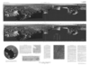
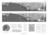
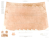
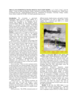
The map sheet "MARS 1:2,000,000 Mouth of Ares and Tiu Valles" presents the mapped area on the planet's northern hemisphere in two different cartographic categories. The Image Map, portraying the…

ISPRS 1999 Assessment of Published Viking Orbiter DEMs derived from Stereo Photogrammetry using MOLA Data thumbnail

ISPRS 1999 Assessment of Published Viking Orbiter DEMs derived from Stereo Photogrammetry using MOLA Data

application/pdf 2 MB

Described the exciting results which have been obtained from the initial set of mainly Northern hemispheric laser altimetry tracks from the MOLA instrument known as the SPO-1 phase. More recently has…

ISPRS 1999 Revision of the Mars Control Net and Global Digital Image Mosaic thumbnail

ISPRS 1999 Revision of the Mars Control Net and Global Digital Image Mosaic

application/pdf 31 kB

In the late 1980s, the USGS, Flagstaff, produced the first in what would become a series of very large, global digital image mosaics of solar system bodies. This Mars mosaicked digital image model…

ISPRS 1999 A Database of Viking Orbiter Image Coverage of Mars for Cartographic and Scientific Use thumbnail

ISPRS 1999 A Database of Viking Orbiter Image Coverage of Mars for Cartographic and Scientific Use

application/pdf 2 MB

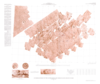
Viking Orbiters 1 and 2 collectively returned more than 46,000 images of Mars between 1976 and 1980. Numerous observation sequences with different objectives resulted in an extremely complex and…

ISPRS 1999 Stereogrammetric Mapping on Mars: Promise, Progress, and Problems thumbnail

ISPRS 1999 Stereogrammetric Mapping on Mars: Promise, Progress, and Problems

application/pdf 46 kB

To assist in landing site selection, we are compiling a suite of stereo images of potential landing sites for the 1998 and 2001 Mars landers. From these, we are using automated stereogrammetry…

ISPRS 1999 The UCL IUS-Tithonium Chasma Digital Elevation Model thumbnail

ISPRS 1999 The UCL IUS-Tithonium Chasma Digital Elevation Model

application/pdf 93 kB

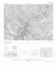
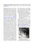
We re-examine a previously unpublished digital elevation model (DEM) of a ~105,000km2 area (figure 1) of Tithonium and Ius Chasma area, produced by the EXODUS (Extraterrestrial Orbital DEMs for…

ISPRS 1999 PIGWAD - Planetary Interactive GIS on the Web Analyzable Database thumbnail

ISPRS 1999 PIGWAD - Planetary Interactive GIS on the Web Analyzable Database

application/pdf 573 kB

We are producing a webbased, user-friendly interface built on a powerful Geographic Information System (GIS), that will integrate statistical and spatial relational tools for analyses of planetary…