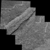
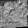
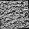
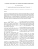
Pre-MB image mosaic of rock
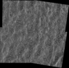
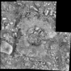
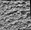
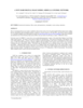
Pre-RAT image mosaic of rock
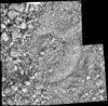
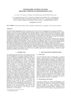
Pre-RAT brush image mosaic of rock
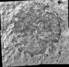
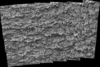
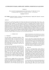
Post-RAT image mosaic of rock
Post-MB image mosaic of soil
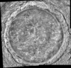
Post-MB image mosaic of rock
Post-APXS image mosaic of rock
NASA's Mars Geodesy/Cartography Working Group (MGCWG), established in 1998 and chaired since 2000 by one of us (TCD), consists of leading researchers in planetary geodesy and cartography at such…
High-precision topographic information from all available data is crucial to many landing site geological and engineering applications. At the same time, precise navigation and localization of the…
The MESSENGER (MErcury Surface, Space ENvironment, GEochemistry, and Ranging) spacecraft will launch in March of 2004, beginning a 5-year journey to Mercury. Mercury has been visited by only one…
This paper presents techniques for automatic mapping of Mars landing sites using surface-based images, i.e., those taken by Mars landers and/or rovers. An innovative method for automatic tie point…
We describe a series of programs and scripts under development for the USGS digital cartography and image processing software system ISIS that will make it possible for users to create digital…
Positional control for MDIM 2.1 comes from a new geodetic/photogrammetric solution of the global Mars Mariner 9 and Viking image control network. The details of this network solution are described…
We describe USGS topomapping of Mars at resolutions from 100 m to 30 µm with data from the latest spacecraft missions. Analysis of NASA 2001 Mars Odyssey Thermal Emission Imaging System (THEMIS)…
Launched in 1996, Mars Global Surveyor (MGS) carries two types of mapping equipments: Mars Orbiter Laser Altimeter (MOLA) and Mar Orbiter Camera (MOC). MOLA collects accurate laser altimetry data…
This paper presents the technology and experimental results for high-precision landing-site mapping and rover localization developed for the ongoing 2003 Mars Exploration Rover (MER) mission. This…
Our project aims to automate Mars mapping and localization using robotic stereo and descent imagery. Stereo vision is a wellstudied domain. However, most efforts aim only at a general scene; little…