Products

110 Results Collapse
Mars Geologic Map of Part of Western Hellas Planitia thumbnail

Mars Geologic Map of Part of Western Hellas Planitia

application/pdf 13 MBJan 07 2007

Introduction Rock units were deposited on Mars by meteorite impact, volcanism, wind, flowing water, standing water, and ice, acting separately or in concert. Hellas Planitia, the deepest tract on…

Mars Geologic Map of MTM -30262 and -30267 Quadrangles, Hadriaca Patera Region thumbnail

Mars Geologic Map of MTM -30262 and -30267 Quadrangles, Hadriaca Patera Region

application/pdf 9 MBJan 07 2007

Introduction Mars Transverse Mercator (MTM) -30262 and -30267 quadrangles cover the summit region and east margin of Hadriaca Patera, one of the Martian volcanoes designated highland paterae. MTM…

Mars Geologic Map of the Northern Plains thumbnail

Mars Geologic Map of the Northern Plains

application/pdf 61 MBJan 05 2005

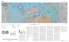
The northern plains of Mars cover nearly a third of the planet and constitute the planet's broadest region of lowlands. Apparently formed early in Mars' history, the northern lowlands served as a…

Mars Geologic Map of Cydonia Mensae-Southern Acidalia Planitia thumbnail

Mars Geologic Map of Cydonia Mensae-Southern Acidalia Planitia

application/pdf 25 MBJan 05 2005

Cydonia Mensae lie adjacent to the boundary separating the highland terrain of western Arabia Terra from the northern lowlands (the dichotomy boundary), where this boundary is gradational rather than…

Mars Geologic Map of the MTM 85080 Quadrangle, Chasma Boreale Region thumbnail

Mars Geologic Map of the MTM 85080 Quadrangle, Chasma Boreale Region

application/pdf 10 MBJan 03 2003

The polar deposits on Mars probably record martian climate history over the last 107 to 109 years (for example, Thomas and others, 1992). The area shown on this map includes polar layered deposits…

Mars Geologic Map of MTM -45252 and -45257 Quadrangles, Reull Vallis Region thumbnail

Mars Geologic Map of MTM -45252 and -45257 Quadrangles, Reull Vallis Region

application/pdf 8 MBJan 03 2003

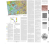
Mars Transverse Mercator (MTM) quadrangles -45252 and -45257 (latitude 42.5° S. to 47.5°S., longitude 250° W. to 260° W.) cover a portion of the highlands of Promethei Terra east of…

Mars Topographic and Color-Coded Contour Maps thumbnail

Mars Topographic and Color-Coded Contour Maps

application/pdf 2 MBJan 03 2003

Mars Geologic Map of MTM -40252 and -40257 Quadrangles, Reull Vallis Region thumbnail

Mars Geologic Map of MTM -40252 and -40257 Quadrangles, Reull Vallis Region

application/pdf 16 MBJan 02 2002

Mars Transverse Mercator (MTM) quadrangles -40252 and -40257 cover a portion of the highlands of Promethei Terra northeast of the Hellas basin. The map area consists of heavily cratered ancient…

Mars Geologic Map Transecting the Highland/Lowland Boundary Zone, Arabia Terra thumbnail

Mars Geologic Map Transecting the Highland/Lowland Boundary Zone, Arabia Terra

application/pdf 36 MBJan 02 2002

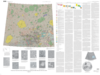
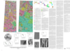
Arabia Terra is a large region of cratered terrane extending from about 20° W. longitude eastward across the prime meridian to about 300° W. longitude for an average east-west width of about…

Ganymede Geologic Maps of the Dardanus Sulcus (Jg-6), Misharu (Jg-10), Nabu (Jg-11), and Namtar (Jg-14) Quadrangles thumbnail

Ganymede Geologic Maps of the Dardanus Sulcus (Jg-6), Misharu (Jg-10), Nabu (Jg-11), and Namtar (Jg-14) Quadrangles

application/pdf 19 MBJan 01 2001

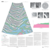
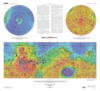
Ganymede is the largest (~5,200 km diameter) known satellite in the Solar System and the third Galilean satellite outward from Jupiter. Its density (1.93 g/cm3) and surface spectral characteristics…

Project Pages

3 Results Collapse

Documents

16 Results Collapse