Products

31 Results Collapse
Io Galileo SSI / Voyager Color Merged Global Mosaic 1km thumbnail

Io Galileo SSI / Voyager Color Merged Global Mosaic 1km

application/isis 189 MB

To present more information-rich views of Io, the global color derived from the Galileo color images was superimposed on the more detailed, higher resolution monochrome mosaics. The procedure adopted…

Io Galileo SSI Global Color Merge Mosaic 1km v1 thumbnail

Io Galileo SSI Global Color Merge Mosaic 1km v1

application/isis 189 MB

Product Information: This global false color mosaic was constructed from low phase angle violet, green, and near-infrared (756 nanometer) images from orbits G2, E6, C9, and C21 of the Galileo…

Mars MC-19 Margaritifer Sinus Nomenclature thumbnail

Mars MC-19 Margaritifer Sinus Nomenclature

application/pdf 3 MBJul 09 2017

Planetary nomenclature, like terrestrial nomenclature, is used to uniquely identify a feature on the surface of a planet or satellite so that the feature can be easily located, described, and…

Mars Geologic Map of the Northern Plains thumbnail

Mars Geologic Map of the Northern Plains

application/pdf 61 MBJan 05 2005

The northern plains of Mars cover nearly a third of the planet and constitute the planet's broadest region of lowlands. Apparently formed early in Mars' history, the northern lowlands served as a…

Europa Voyager / Galileo Image Mosaic Globe thumbnail

Europa Voyager / Galileo Image Mosaic Globe

application/pdf 5 MB

The images used for the base of this globe were chosen from coverage supplied by the Galileo solid-state imaging (SSI) camera and Voyager 1 and 2 spacecraft. The individual images were…

Mars Viking Globe thumbnail

Mars Viking Globe

application/pdf 3 MB

The photomosaic that forms the base for this globe was created by merging two global digital image models (DIM's) of Mars, a medium-resolution monochrome mosaic processed to emphasize topographic…

Venus Magellan Globe thumbnail

Venus Magellan Globe

application/pdf 8 MB

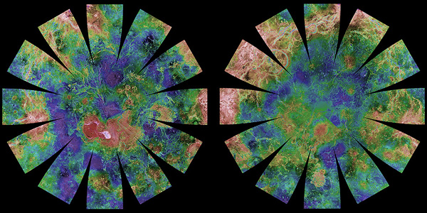
The images used for the base of this globe show the northern and southern hemispheres of Venus as revealed by more than a decade of radar investigations culminating in the 1990-1994 Magellan mission.…

Mars Global Surveyor MOLA Globe thumbnail

Mars Global Surveyor MOLA Globe

application/pdf 9 MB

The color shaded relief image used as the base for this globe has a resolution of 32 pixels per degree (approximately 1850 m/pixel), and was produced and supplied by the MOLA Science Team. The image…

Moon Clementine Topographic Globe thumbnail

Moon Clementine Topographic Globe

application/pdf 3 MB

The photomosaic that forms the base for this globe combines a gray-shaded relief airbrush image with color-coded topographic data. The shaded relief data provide interpretations of lunar morphology…

Project Pages

6 Results Collapse
Interactive GIS Map of Venus thumbnail

Interactive GIS Map of Venus

http://astrogeology.usgs.gov/facilities/mrctr/venus-online-map

Layers available for download from:USGS AstrogeologyData Portal: Astropediahistorical FTP downloads

Interactive GIS Map of the Moon thumbnail

Interactive GIS Map of the Moon

http://astrogeology.usgs.gov/facilities/mrctr/moon-online-map

Layers available for download from:USGS AstrogeologyData Portal: Astropediahistorical FTP downloads

Interactive GIS Map of Mars thumbnail

Interactive GIS Map of Mars

http://astrogeology.usgs.gov/facilities/mrctr/mars-online-map

Layers available for download from:USGS AstrogeologyData Portal: Astropediahistorical FTP downloads

Mars Dunes

http://astrogeology.usgs.gov/geology/mars-dunes

Sand dunes are among the most widespread aeolian features present on Mars, serving as unique indicators of the interaction between the atmosphere and surface. On a planetary body, dunes accumulate…

Mars Ice

http://astrogeology.usgs.gov/geology/mars-ice

North Pole Consortium Meetings Instruments and Data Tharsis Region South Pole South Pole Cryptic Region South Pole Recession

Maps and Globes thumbnail

Maps and Globes

http://astrogeology.usgs.gov/maps/planetary-maps-and-globes

Download, print, and make your own planetary globes! The number, size, and placement of text annotations were chosen to provide a general orientation of prominent features on a 12-inch globe. …

Documents

5 Results Collapse
ISPRS 1999 Triaxial Ellipsoid as a Reference-Surface on Mars Mapping thumbnail

ISPRS 1999 Triaxial Ellipsoid as a Reference-Surface on Mars Mapping

application/pdf 59 kB

At the development of a mathematical basis of cartographic products the problems of selection of a reference-surface system, system of coordinates, and also selection and elaboration of cartographic…

ISPRS 1999 Stereogrammetric Mapping on Mars: Promise, Progress, and Problems thumbnail

ISPRS 1999 Stereogrammetric Mapping on Mars: Promise, Progress, and Problems

application/pdf 46 kB

To assist in landing site selection, we are compiling a suite of stereo images of potential landing sites for the 1998 and 2001 Mars landers. From these, we are using automated stereogrammetry…

ISPRS 2004 Geomorphometric Mapping of Grand Canyon from the 1-Degree USGS DEMs thumbnail

ISPRS 2004 Geomorphometric Mapping of Grand Canyon from the 1-Degree USGS DEMs

application/pdf 946 kB

In a previous research effort a terrain partition framework was defined allowing the partition of the landscape of Valles Marineris chasma (an elongated steep-sided depression located in Mars) to…