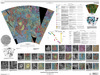
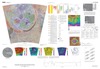
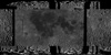
This publication provides a geological map of Lada Terra quadrangle (V56), a portion of the southern hemisphere of Venus that extends from lat 50° S. to 70° S. and from long 0° E. to 60° E. V56…
The Hecate Chasma quadrangle (V-28) extends from lat 0° to 25° N. and from long 240° E. to 270° E. The quadrangle was mapped at 1:5,000,000 scale as part of the National Aeronautics and Space…
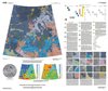
The Metis Mons quadrangle (V6) in the northern hemisphere of Venus (lat 50° to 75° N., long 240° to 300° E.) includes a variety of coronae, large volcanoes, ridge and fracture (structure) belts,…
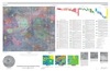
The Ganiki Planitia (V-14) quadrangle on Venus, which extends from 25° N. to 50° N. and from 180° E. to 210° E., derives its name from the extensive suite of plains that dominates the geology of…
Artemis, named for the Greek goddess of the hunt, represents an approximately 2,600 km diameter circular feature on Venus, and it may represent the largest circular structure in our solar system.…
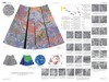
The Greenaway quadrangle (V-24; lat 0 degrees -25 degrees N., long 120 degrees -150 degrees E.), Venus, derives its name from the impact crater Greenaway, centered at lat 22.9 degrees N., long 145.1…
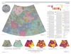
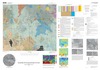
The Lakshmi Planum quadrangle is in the northern hemisphere of Venus and extends from lat 50 degrees to 75 degrees N., and from long 300 degrees to 360 degrees E. The elevated volcanic plateau of…
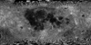
Product Information: This near-global mosaic was generated using data from the SELenological and Engineering Explorer (SELENE) “Kaguya” Terrain Camera (TC) instrument. TC source data originated…
Topographic mapping of icy satellites is a critical tool for evaluation of geologic problems ranging from the origin of ionian mountains to the thickness of floating ice shells. With the lack of…
After the initial proposal of Contact 1 and 2, previously published papers about ocean on Mars can basically be divided in two groups. The first one was based on shorelines theory, however,…
Many indicators for ocean on Mars were proposed: outflow channels and features related to the evolution of standing bodies of water (polygons, lobate impact craters), features consistent with the…
The MESSENGER (MErcury Surface, Space ENvironment, GEochemistry, and Ranging) spacecraft will launch in March of 2004, beginning a 5-year journey to Mercury. Mercury has been visited by only one…
Recently, mathematical approach was proposed providing a way to compute how deep Martian ocean was during each period of the planet history, including the probability that ocean existed once. An…
Recently, mathematical approach was proposed providing a way to compute how deep Martian ocean was during each period of the planet history, including the probability that ocean existed once.…
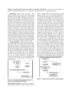
Impact craters are crucial landmarks for geodetic control as well as being interesting geological research targets themselves. Several methods have been developed to automatically detect impact…
GIS-like tools have existed in the computer age since scientists have been displaying images or comparing digital datasets. Whether it was a program on a mainframe to draw a satellite image to…
Planetary exploration missions have returned a wealth of imagery data over the last 40 years. The problem is how to make best use of it all. Thoroughly analyzing such large datasets manually is…
The Mars Crater Morphology Consortium was formed in 1997 to facilitate exchange of martian impact crater data among researchers through standardizing nomenclature, integrating crater databases into…