During the Clementine Mission both oblique and vertical multispectral images were collected. The oblique and vertical images from a single spectral band collected during the same orbit form a stereo…
In the field of Earth observation and planetary exploration, a number of spacecrafts have been equipped in the last years with various multispectral and/or hyperspectral optical instruments spanning…
Digitization and cartographic processing of 5 Lunar Orbiter (LO) IV frames (109H, 110H, 114H, 115H, and 114M) are now complete, and these data are available online at…
The USGS is producing digital elevation models (DEM) and topographic maps of Mars at scales of 1:250,000 to 1:1,000,000. The initial source material will be Viking Orbiter images, with a later…
NASA's SPICE system is used as the mechanism for capturing, archiving and disseminating a variety of ancillary and engineering information needed by scientists involved in mission design, observation…
Study of the origin, composition and alteration of planetary regoliths and soils is a key to set constraints on the formation and evolution of telluric planets. Surfaces are indeed complex interfaces…
Viking Orbiters 1 and 2 collectively returned more than 46,000 images of Mars between 1976 and 1980. Numerous observation sequences with different objectives resulted in an extremely complex and…
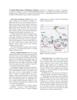
In this abstract we report on our initial experiences performing stereotopographic mapping of Mars with high-resolution images from the Mars Global Surveyor Mars Orbiter Camera Narrow-Angle subsystem…
We describe our initial experiences producing controlled digital elevation models (DEMs) of Mars with horizontal resolutions of ≤10 m and vertical precisions of ≤2 m. Such models are of intense…
In the late 1980s, the USGS, Flagstaff, produced the first in what would become a series of very large, global digital image mosaics of solar system bodies. This Mars mosaicked digital image model…