Products

69 Results Collapse
Moon Lunar Orbiter - Clementine UVVISv2 Hybrid Mosaic 59m v1 thumbnail

Moon Lunar Orbiter - Clementine UVVISv2 Hybrid Mosaic 59m v1

application/isis 16 GB

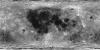
Product Information: The is a blend (or overlay) of the U.S. Geological Survey (USGS) Clementine Ultraviolet/Visible (UVVIS) V2 mosaic and the original USGS Lunar Orbiter mosaic. The Clementine 750…

Moon Clementine NIR Empirical Calibration 500m v1 thumbnail

Moon Clementine NIR Empirical Calibration 500m v1

application/isis 2 GB

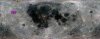
Product Information: This mosaic represents a reduced-resolution version of the empirical calibration Clementine near-infrared (NIR) mosaic processed to 500 meters per pixel (m) spatial resolution…

Moon Clementine Topographic Maps thumbnail

Moon Clementine Topographic Maps

application/pdf 5 MB

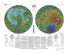
This sheet is one in a series of topographic maps that presents colorcoded topographic data digitally merged with shaded relief data. The figure for the Moon, used for the computation of the map…

Moon Clementine Topographic Globe thumbnail

Moon Clementine Topographic Globe

application/pdf 3 MB

The photomosaic that forms the base for this globe combines a gray-shaded relief airbrush image with color-coded topographic data. The shaded relief data provide interpretations of lunar morphology…

Lunar Consortium Data Historical Archive thumbnail

Lunar Consortium Data Historical Archive

application/zip 89 kB

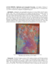
Assorted Lunar Images and Data from 1965 to 1992 Presented here are safed versions of variety of data selected from a collection of data commonly referred to as the Lunar Consortium Data. This…

Moon SELENE Kaguya TC Morning Global Mosaic 474m v2 thumbnail

Moon SELENE Kaguya TC Morning Global Mosaic 474m v2

application/isis 506 MB

Product Information: This near-global mosaic was generated using data from the SELenological and Engineering Explorer (SELENE) “Kaguya” Terrain Camera (TC) instrument. TC source data originated…

Moon SELENE Kaguya TC Morning Global Mosaic 474m v4 thumbnail

Moon SELENE Kaguya TC Morning Global Mosaic 474m v4

application/isis 506 MB

Product Information: This near-global mosaic was generated using data from the SELenological and Engineering Explorer (SELENE) “Kaguya” Terrain Camera (TC) instrument. TC source data originated…

Project Pages

5 Results Collapse

Documents

21 Results Collapse
ISPRS 2001 Validation of the USGS Sensor Model for Topographic Mapping of Venus Using Magellan Radar Stereoimagery thumbnail

ISPRS 2001 Validation of the USGS Sensor Model for Topographic Mapping of Venus Using Magellan Radar Stereoimagery

application/pdf 986 kB

The Magellan spacecraft went into Venus orbit in 1990 and by 1992 had made three complete cycles of polar orbits, each cycle covering the full range of longitudes. During this time the spacecraft…

ISPRS 2001 Lunar Orbiter Digitization and Cartographic Processing thumbnail

ISPRS 2001 Lunar Orbiter Digitization and Cartographic Processing

application/pdf 377 kB

Digitization and cartographic processing of 5 Lunar Orbiter (LO) IV frames (109H, 110H, 114H, 115H, and 114M) are now complete, and these data are available online at…

ISPRS 2001 SPICE Products and Services Available to the Planetary Cartography Community thumbnail

ISPRS 2001 SPICE Products and Services Available to the Planetary Cartography Community

application/pdf 5 kB

NASA's SPICE system is used as the mechanism for capturing, archiving and disseminating a variety of ancillary and engineering information needed by scientists involved in mission design, observation…

ISPRS 2002 High-Resolution Topomapping of Mars Orbiter Camera Narrow-Angle Images thumbnail

ISPRS 2002 High-Resolution Topomapping of Mars Orbiter Camera Narrow-Angle Images

application/pdf 800 kB

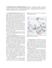
We describe our initial experiences producing controlled digital elevation models (DEMs) of Mars with horizontal resolutions of ≤10 m and vertical precisions of ≤2 m. Such models are of intense…

ISPRS 2003 A Virtual Observatory of Planetary Surfaces thumbnail

ISPRS 2003 A Virtual Observatory of Planetary Surfaces

application/pdf 676 kB

Study of the origin, composition and alteration of planetary regoliths and soils is a key to set constraints on the formation and evolution of telluric planets. Surfaces are indeed complex interfaces…

ISPRS 2003 A Systematic Approach for Optimizing Spectral and Spatial Matching Between Independent Datasets thumbnail

ISPRS 2003 A Systematic Approach for Optimizing Spectral and Spatial Matching Between Independent Datasets

application/pdf 567 kB

In the field of Earth observation and planetary exploration, a number of spacecrafts have been equipped in the last years with various multispectral and/or hyperspectral optical instruments spanning…

ISPRS 2004 Multi-Image Shape from Shading, Derivation of Planetary Digital Terrain Models Using Clementine Images thumbnail

ISPRS 2004 Multi-Image Shape from Shading, Derivation of Planetary Digital Terrain Models Using Clementine Images

application/pdf 627 kB

In many cases, the derivation of high-resolution digital terrain models (DTMs) from planetary surfaces using only conventional digital image matching is a problem. The matching methods need at least…

ISPRS 2004 Performance of Automatic Tie Point Extraction using HRSC Imagery of the Mars Express Mission thumbnail

ISPRS 2004 Performance of Automatic Tie Point Extraction using HRSC Imagery of the Mars Express Mission

application/pdf 340 kB

In January 2004 the first European interplanetary spacecraft, Mars Express, was inserted successfully into a Martian orbit. The multiline scanner HRSC (High Resolution Stereo Camera) on board of…