Products

83 Results Collapse
PDS4 Training Course thumbnail

PDS4 Training Course

application/vnd.openxmlformats-officedocument.presentationml.presentation 200 kB

Imaging Node Status, Mar10 thumbnail

Imaging Node Status, Mar10

application/vnd.openxmlformats-officedocument.presentationml.presentation 1 MB

PowerPoint Presentation thumbnail

PowerPoint Presentation

application/vnd.openxmlformats-officedocument.presentationml.presentation 16 MB

Modeling and Adjustment of THEMIS IR Line Scanner Camera Image Measurements thumbnail

Modeling and Adjustment of THEMIS IR Line Scanner Camera Image Measurements

application/pdf 269 kB

The overall problem we’re solving is that we want to be able to set up the relationships between the coordinates of arbitrary physical points in space (e.g. ground points) and their coordinates on…

Enceladus Cassini ISS Gridded Topography 2.2km v1 thumbnail

Enceladus Cassini ISS Gridded Topography 2.2km v1

application/isis 1 kBAug 28 2020

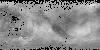
This 2.5D topographic model of Enceladus was created by first generating a fully 3D shape (radius) model from a dense network of image tie points and photogrammetrically solving for point latitude,…

Enceladus Cassini ISS Gridded Radius 2.2km v1 thumbnail

Enceladus Cassini ISS Gridded Radius 2.2km v1

application/isis 1 kBAug 28 2020

This 2.5D shape model of Enceladus was generated by interpolating the associated 3D point cloud of latitude, longitude, radius values, minus the mean radius of Enceldaus (251500 meters), to a regular…

Enceladus Cassini ISS Global Mosaic HPF 110m v1 thumbnail

Enceladus Cassini ISS Global Mosaic HPF 110m v1

application/isis 1 kBOct 22 2018

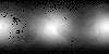
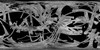
Product Information: This mosaic represents the completion of a global control network of Enceladus containing Cassini Imaging Science Subsystem (ISS) images. A total of 586 images in CLR, GRN, UV3,…

Titan Cassini ISS Global Mosaic 4005m v1 thumbnail

Titan Cassini ISS Global Mosaic 4005m v1

application/isis 8 MBOct 10 2015

Product Information: This global digital map of Saturn's moon Titan was created using images taken by the Cassini spacecraft's Imaging Science Subsystem (ISS). The map was produced in June 2015…

Second Planetary Data Workshop Abstract Volume Draft thumbnail

Second Planetary Data Workshop Abstract Volume Draft

application/pdf 5 MBJul 07 2015

This is a draft volume for the abstracts presented at the 2nd Planetary Data Workshop in 2015 host in Flagstaff, AZ.

Titan Cassini SAR - HiSAR Global Mosaic 351m v1 thumbnail

Titan Cassini SAR - HiSAR Global Mosaic 351m v1

application/isis 1,013 MBJan 01 2015

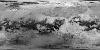
Product Information: This global map of Titan is a preliminary product showing coverage from Synthetic Aperture Radar (SAR) and High Altitude Synthetic Aperture Radar (HiSAR) images at a pixel…

Project Pages

3 Results Collapse

Documents

14 Results Collapse