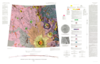
The northern plains of Mars cover nearly a third of the planet and constitute the planet's broadest region of lowlands. Apparently formed early in Mars' history, the northern lowlands served as a…
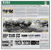
The Cassini mission has returned an abundance of data about the surface of Titan. To maximize the science return from these data and to assist with planning for Cassini and future missions, we have…
Cassini RADAR SARtopo and altimetry data are used to construct a global gridded 1 x 1° elevation map, for use in Global Circulation Models, hydrological models and correlative studies. The data are…
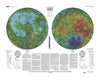
This sheet is one in a series of topographic maps that presents colorcoded topographic data digitally merged with shaded relief data. The figure for the Moon, used for the computation of the map…
These files are part of the Global Topographic Data Record (GTDR) series of Digital Map Products (DMP) produced by the Cassini RADAR Science Team. They contain a variety of different models for the…
Product Information: This global digital mosaic uses 25 images from Voyager 1 and is a sinusoidal projection with a resolution of 833 meters per pixel (m). Digital image processing of the Voyager…
This image mosaic is one of several products created as the first step of cartography planning in support of the Cassini-Huygens Mission to Saturn & Titan. The data included in this mosaic were…