Product Information: This global mosaic of Ganymede utilizes the best image quality and moderate resolution coverage supplied by Galileo Solid-State Imaging (SSI) and Voyager 1 and 2. The image data…
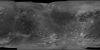
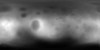
Product Information: This global map of Iapetus was created using images taken during Cassini spacecraft flybys, with Voyager images filling in the poles. The map is a Simple Cylindrical projection…
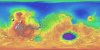
Product Information: This digital elevation model (DEM) is based on data from the Mars Orbiter Laser Altimeter (MOLA; Smith et al., 2001), an instrument on NASA’s Mars Global Surveyor (MGS)…
Product Information: Voyager 2 data was used to construct the best-ever global color map of Triton. This map has a resolution of 1,970 feet (600 meters per pixel [m]). Color was synthesized by…
The Apollo Metric Cameras were carried on the Apollo 15, 16, and 17 missions to map Earth’s Moon with a high degree of geometric fidelity. This PDS volume contains the "Apollo 15, 16, and 17…
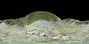
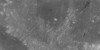
Product Information: Images from the European Space Agency's High Resolution Stereo Camera (HRSC) aboard the Mars Express were used to obtain 3-dimensional coordinates of surface points of Phobos.…
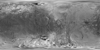
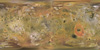
This global image map of Mars has a resolution of 256 pixels/degree (scale approximately 231 m/pixel at the equator). The black-and-white mosaic is processed to emphasize local topographic features.…
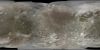
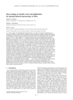
Product Information: This global false color mosaic was constructed from low phase angle violet, green, and near-infrared (756 nanometer) images from orbits G2, E6, C9, and C21 of the Galileo…
Product Information: This map is based on data from the Mars Orbiter Laser Altimeter (MOLA) (Smith, et al., 2001), an instrument on NASA’s Mars Global Surveyor (MGS) spacecraft (Albee, et al.,…
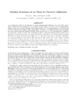
The Mars Crater Morphology Consortium was formed in 1997 to facilitate exchange of martian impact crater data among researchers through standardizing nomenclature, integrating crater databases into…
In many cases, the derivation of high-resolution digital terrain models (DTMs) from planetary surfaces using only conventional digital image matching is a problem. The matching methods need at least…
Positional control for MDIM 2.1 comes from a new geodetic/photogrammetric solution of the global Mars Mariner 9 and Viking image control network. The details of this network solution are described…
We describe USGS topomapping of Mars at resolutions from 100 m to 30 µm with data from the latest spacecraft missions. Analysis of NASA 2001 Mars Odyssey Thermal Emission Imaging System (THEMIS)…
Launched in 1996, Mars Global Surveyor (MGS) carries two types of mapping equipments: Mars Orbiter Laser Altimeter (MOLA) and Mar Orbiter Camera (MOC). MOLA collects accurate laser altimetry data…