Lunar and Planetary Cartographic Catalog
Products
55 Results
Collapse
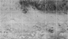
Southern high-latitude band at Phaethontis Quadrangle (MC24)
image/gif 382 kB
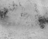
Changes in the equatorial band near 30S, 180W
image/gif 930 kB
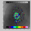
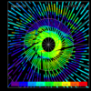
Geometric distribution of cold spots colored relative to T18-T25
image/gif 93 kB
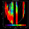
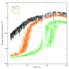
Graph of slab ice distribution as a function of season and latitude
image/gif 41 kB
Animation of 1999 and 2001 north pole mosaics
image/gif 147 kB
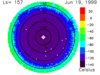
1999 Plot of South Pole Bolometer Temperatures
image/gif 16 kB
Animation of 1999 South Polar Cap Recession
image/gif 1 MB
Animation of 1997 South Polar Cap Recession
image/gif 2 MB
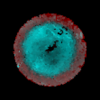
North polar lambert albedo mosaic May, 1999
image/gif 67 kB
North polar lambert albedo mosaic April, 2001
image/gif 79 kB
1
…
3
4
5
6
Documents
1 Result
Collapse
ISIS
Planetary Nomenclature
Map a Planet 2
PDS Cartography and Imaging Science Node
RPIF
Photogrammetry Guest Facility
PILOT
MRCTR GIS Lab