ISPRS 1998 Mars Pathfinder: Photogrammetric Processing of Lander Images and Cartographic Analysis of the Landing Site from Orbit
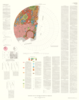
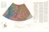
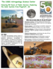
application/pdf 66 kBFollowing the successful landing of the Mars Pathfinder, DLR has carried out a comprehensive study of the Pathfinder landing site in terms of geology, mineralogy, and surface photometric properties.…