ISPRS 1999 Revision of the Mars Control Net and Global Digital Image Mosaic
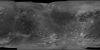
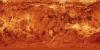
application/pdf 31 kBIn the late 1980s, the USGS, Flagstaff, produced the first in what would become a series of very large, global digital image mosaics of solar system bodies. This Mars mosaicked digital image model…