Product Information: This digital elevation model (DEM) was initially created as an assessment tool for the entry, descent, and landing (EDL) analysis conducted by the Mars Science Laborarory (MSL)…
We have created 39 regional semi-controlled CTX mosaics at 5m/pixel for the 2015 proposed Mars Human Exploration zones. They are individually available for download in GeoTiff format from the "Online…
Product Information: This digital elevation model (DEM) is based on data from the Lunar Orbiter Laser Altimeter (LOLA; Smith et al., 2010), an instrument on the National Aeronautics and Space Agency…
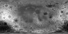
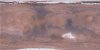
Product Information: This mosaic of Phobos was created by compiling updated versions of Viking high-resolution mosaics and selecting the best high-resolution images from other spacecraft to…
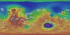
Product Information: This global image map of Mars has a resolution of 256 pixels/degree (scale approximately 232 meters per pixel (m) at the equator). The colorized mosaic was completed by NASA…
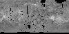
Product Information: This global mosaic of Ganymede utilizes the best image quality and moderate resolution coverage supplied by Galileo Solid-State Imaging (SSI) and Voyager 1 and 2. The image data…
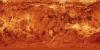
Product Information: This mosaic was created from the Magellan Full resolution Basic Image Data Records (F-BIDRs), the highest resolution radar images of the Venus surface (~75 meters per pixel…
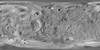
This mosaic represents the Thermal Emission Imaging System (THEMIS) -daytime infrared (IR) 100 meter/pixel mosaic (version 12) released in the summer of 2014 by Arizona State University. Values…
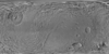
Product Information: This synthetic colorized version of the C3-MIDR mosaic was developed to simulate the surface of Venus. This mosaic was created from the Magellan Full resolution Basic Image Data…
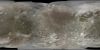
Product Information: This global map of Saturn's moon Tethys was created using images taken during Cassini spacecraft flybys which mostly occurred during the Solstice mission extension. The map is…