Products

260 Results Collapse
Venus Geologic Map of the Niobe Planitia Quadrangle (V-23) thumbnail

Venus Geologic Map of the Niobe Planitia Quadrangle (V-23)

application/pdf 87 MBJan 09 2009

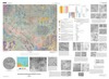
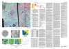
The Niobe Planitia quadrangle (V-23) encompasses approximately 8,000,000 km2 of the Venusian equatorial region extending from lat 0 deg to 25 deg N. and from long 90 deg to 120 deg E. (approximately…

Mars Geologic Map of MTM -20012 and -25012 Quadrangles, Margaritifer Terra Region thumbnail

Mars Geologic Map of MTM -20012 and -25012 Quadrangles, Margaritifer Terra Region

application/pdf 12 MBJan 09 2009

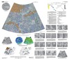
Mars Transverse Mercator (MTM) -20012 and -25012 quadrangles (lat 17.5 deg - 27.5 deg S., long 345 deg - 350 deg E.) cover a portion of Margaritifer Terra near the east end of Valles Marineris. The…

Mars Geologic Map of MTM 35337, 40337, and 45337 Quadrangles, Deuteronilus Mensae Region thumbnail

Mars Geologic Map of MTM 35337, 40337, and 45337 Quadrangles, Deuteronilus Mensae Region

application/pdf 9 MBJan 09 2009

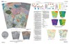
Deuteronilus Mensae, first defined as an albedo feature at lat 35.0 deg N., long 5.0 deg E., by U.S. Geological Survey (USGS) and International Astronomical Union (IAU) nomenclature, is a gradational…

Venus Geologic Map of the Helen Planitia Quadrangle (V-52) thumbnail

Venus Geologic Map of the Helen Planitia Quadrangle (V-52)

application/pdf 19 MBJan 08 2008

The Magellan spacecraft orbited Venus from August 10, 1990, until it plunged into the Venusian atmosphere on October 12, 1994. Magellan Mission objectives included (1) improving the knowledge of the…

Venus Geologic Map of the Meskhent Tessera Quadrangle (V-3) thumbnail

Venus Geologic Map of the Meskhent Tessera Quadrangle (V-3)

application/pdf 45 MBJan 08 2008

The Magellan spacecraft orbited Venus from August 10, 1990, until it plunged into the Venusian atmosphere on October 12, 1994. Magellan Mission objectives included (1) improving the knowledge of the…

Venus Geologic Map of the Sif Mons Quadrangle (V-31) thumbnail

Venus Geologic Map of the Sif Mons Quadrangle (V-31)

application/pdf 15 MBJan 07 2007

The Magellan spacecraft orbited Venus from August 10, 1990, until it plunged into the Venusian atmosphere on October 12, 1994. Magellan Mission objectives included (1) improving the knowledge of the…

Mars Geologic Map of MTM -30262 and -30267 Quadrangles, Hadriaca Patera Region thumbnail

Mars Geologic Map of MTM -30262 and -30267 Quadrangles, Hadriaca Patera Region

application/pdf 9 MBJan 07 2007

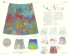
Introduction Mars Transverse Mercator (MTM) -30262 and -30267 quadrangles cover the summit region and east margin of Hadriaca Patera, one of the Martian volcanoes designated highland paterae. MTM…

Mars Geologic Map of Part of Western Hellas Planitia thumbnail

Mars Geologic Map of Part of Western Hellas Planitia

application/pdf 13 MBJan 07 2007

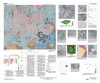
Introduction Rock units were deposited on Mars by meteorite impact, volcanism, wind, flowing water, standing water, and ice, acting separately or in concert. Hellas Planitia, the deepest tract on…

Venus Geologic Map of the Mead Quadrangle (V-21) thumbnail

Venus Geologic Map of the Mead Quadrangle (V-21)

application/pdf 19 MBJan 06 2006

The Magellan spacecraft orbited Venus from August 10, 1990, until it plunged into the Venusian atmosphere on October 12, 1994. Magellan Mission objectives included (1) improving the knowledge of the…

Project Pages

23 Results Collapse

Documents

3 Results Collapse