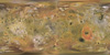
Product Information: This global false color mosaic was constructed from low phase angle violet, green, and near-infrared (756 nanometer) images from orbits G2, E6, C9, and C21 of the Galileo…
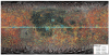
This global map of Callisto utilizes the best image quality and moderate resolution coverage supplied by Galileo SSI (Solid State Imaging instrument) and Voyager 1 and 2. The image processing was…
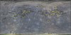
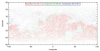
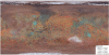
These water maps and their ancillary data were prepared for studying the effects of Earth's magnetotail on the formation of the lunar surface water by Dr. Shuai Li at University of Hawaii. It is…
In this study, 96 digital terrain models (DTM/DEMs) and derived orthorecitifed images of Mercury were created using the NASA Ames Stereo Pipeline, using 1456 pairs of stereo images from the Mercury…
Project Information: The Titan Fluvial GIS Mapping Project follows previous work by Barnes et al., 2007, Lorenz et al., 2008 & Burr et al., 2009, to map fluvial features on Titan. The Cassini Radio…
Product Information: This research is a multi-stage process of identification and analysis. It involves going through global Thermal Emission Imaging System (THEMIS) daytime thermal infrared mosaics…
Product Information: The catalogues by McDowell, Rodionova, and Head have been integrated with the results of a Crater Shape-based interpolation crater detection algorithm (CDA) and Lunar Orbiter…
Product Information: Initially, a catalogue of 17,582 Martian craters has been developed for objective evaluation of crater detection algorithms (CDAs; Salamuniccar and Loncaric, 2008a). After…
Product Information: This is a shaded-relief of a original polar digital elevation model (DEM) from the Lunar Orbiter Laser Altimeter (LOLA; Smith et al., 2010), an instrument on the National…
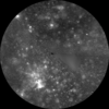
This basemap of Jupiter’s moon Io was produced by combining the best images from both the Voyager 1 and Galileo Missions. Although the subjovian hemisphere of Io was poorly seen by Galileo,…