In this abstract we report on our initial experiences performing stereotopographic mapping of Mars with high-resolution images from the Mars Global Surveyor Mars Orbiter Camera Narrow-Angle subsystem…
A basic requirement for the planning of future, perhaps even manned Mars missions are precise and high resolution maps of our neighbour planet and, especially, of the landing area. Here we present a…
The USGS is producing digital elevation models (DEM) and topographic maps of Mars at scales of 1:250,000 to 1:1,000,000. The initial source material will be Viking Orbiter images, with a later…
Recent geodetic observations of Mars by the Mars Global Surveyor spacecraft, particularly the altimetry and gravity experiments, have provided a new framework in which Mars may be geodetically…
The MGS Orbiter is carrying the high-precision Mars Orbiter Laser Altimeter (MOLA) which, when combined with precision reconstructed orbital data and telemetered attitude data, provides a tie between…
There are many similarities between the Mars Surveyor '01 (MS '01) landing site selection process and that of Mars Pathfinder. The selection process includes two parallel activities in which…
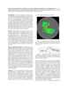
To assist in landing site selection, we are compiling a suite of stereo images of potential landing sites for the 1998 and 2001 Mars landers. From these, we are using automated stereogrammetry…
The Mars Orbiter Laser Altimeter (MOLA) on the Mars Global Surveyor (MGS) mission will produce a precision global geodetic control network for Mars of 30,000 - 50,000 points which will be accurate to…
A comparison of the MOLA topographic profile data with existing digital topography indicates the presence of both systematic and significant local and regional differences. These differences are in…
Since arrival at Mars in Sept. 1997 the Mars Orbiter Laser Altimeter (MOLA) on the Mars Global Surveyor (MGS) spacecraft has obtained a number of topographic profiles across the northern hemisphere…