Project sheet with instructions for creating the Viking and Global Surveyor Mars globes using tennis balls.
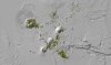
Product Information: This data set represents ongoing identification, characterization, and mapping of small vents across the Tharsis province utilizes Mars Orbiter Laser Altimeter (MOLA), Thermal…
Launched in 1996, Mars Global Surveyor (MGS) carries two types of mapping equipments: Mars Orbiter Laser Altimeter (MOLA) and Mar Orbiter Camera (MOC). MOLA collects accurate laser altimetry data…
One of the primary tasks of the Mars Global Surveyor (MGS) mission is to produce precision mapping products over the Mars surface [Albee et al, 2001]. Properties and capabilities of MOC NA (Mars…
The high resolution instruments on board the Mars Global Surveyor (MGS) provide the necessary data to survey the Martian topographic surface in the finest detail so far [Albee, et al, 2002]. However,…
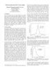
We describe our initial experiences producing controlled digital elevation models (DEMs) of Mars with horizontal resolutions of ≤10 m and vertical precisions of ≤2 m. Such models are of intense…
The current Mars Global Survey (MGS) mission has been collecting high resolution digital images (MOC) and laser ranges (MOLA). The processing MOLA range data results in a global digital elevation…
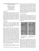
A basic requirement for the planning of future Mars missions are precise and high resolution maps, especially, of the landing site area. We present a new digital orthoimage map of Mars using data…
Though the primary focus at Malin Space Science Systems (MSSS) is on building and operating instruments through the archiving of raw data, we have also pursued research interests in planetary…
The stereo photogrammetric observable equations are presented relating control point image location to camera distortions, camera pointing, spacecraft position, Mars-fixed areocentric control point…
The current global spatial control net of Mars provides the geodetic basis for an orthoimage map composed of image data sets obtained from VIKING missions from 1976 to 1980. This map is not…