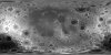
Product Information: This digital elevation model (DEM) is based on data from the Lunar Orbiter Laser Altimeter (LOLA; Smith et al., 2010), an instrument on the National Aeronautics and Space Agency…
Ganymede is the largest satellite of Jupiter, and its icy surface has been formed through a variety of of impact cratering, tectonic, and possibly cryovolcanic processes. The history of…
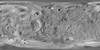
This product is a daytime infrared image mosaic generated using Thermal Emission Imaging System (THEMIS) images from the 2001 Mars Odyssey orbiter mission. The mosaic is generated at the full…
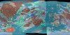
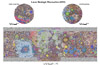
These maps are a series of geologic maps that cover the entire Moon at a scale of 1:5,000,000 originally created in the 1970's. Because of increasing emphasis on lunar studies from recent orbital…
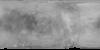
Product Information: This mosaic of Phobos was created by compiling updated versions of Viking high-resolution mosaics and selecting the best high-resolution images from other spacecraft to…
Io, discovered by Galileo Galilei on January 7-13, 1610, is the innermost of the four Galilean satellites of the planet Jupiter. It is the most volcanically active object in the Solar System, as…
Product Information: This is a colorized shaded-relief of a original polar digital elevation model (DEM) from the Lunar Orbiter Laser Altimeter (LOLA; Smith et al., 2010), an instrument on the…
Product Information: This global map base of Europa utilizes the best image quality and moderate resolution coverage supplied by the Galileo SSI (Solid-State Imaging) instrument and Voyager 1 and 2.…
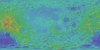
Product Information: This global image map of Mars has a resolution of 256 pixels/degree (scale approximately 232 meters per pixel (m) at the equator). The colorized mosaic was completed by NASA…
A digital adaptation of the hard-copy Viking Orbiter-based geologic maps of Mars. The western equatorial region was originally mapped by David H. Scott and K. L. Tanaka (USGS I-1802-A, 1986, 1:15M…