This orthorectified image was created by projecting an image from the Mars Reconnaissance Orbiter Context Camera (CTX) onto a Digital Terrain Model (DTM). The DTM is available under the “Derived…
Product Information: Using the Integrated Software for Imagers and Spectrometers (ISIS3) and observations from Mercury Dual Imaging System (MDIS) narrow-angle camera (NAC) and multispectral…
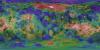
This is a colorized shaded-relief of the original Ceres digital terrain model (DTM). This DTM was created from the Dawn High Altitude Mapping orbit (HAMO) Framing Camera 2 (FC2) images and derived by…
Product Information: This digital terrain model (DTM) of Ceres based on the Dawn High Altitude Mapping Orbit (HAMO) Framing Camera 2 (FC2) images and derived by using the stereo photogrammetry (SPG)…
Product Information: This is a colorized shaded-relief of the original digital elevation model (DEM). Using the Integrated Software for Imagers and Spectrometers (ISIS3) and observations from…
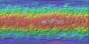
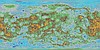
Product Information: Voyager 2 data was used to construct the best-ever global color map of Triton. This map has a resolution of 1,970 feet (600 meters per pixel [m]). Color was synthesized by…
Product Information: This product represents a near-global lunar topography from stereo image data acquired by the Wide-angle Camera (WAC) of the Lunar Reconnaissance Orbiter Camera (LROC) system…
Product Information: This color mosaic is comprised of photometrically corrected I/F (radiance factor) for 3 narrow-band color filters of the Mercury Dual Imaging System (MDIS) Wide Angle Camera…
Product Information: This mosaic was created from the Magellan Full resolution Basic Image Data Records (F-BIDRs), the highest resolution radar images of the Venus surface (~75 meters per pixel…