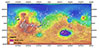
Product Information: The Lunar Orbiter Laser Altimeter (LOLA) and SELenological and Engineering Explorer (SELENE) Kaguya Teams have created an improved lunar digital elevation model (DEM) covering…
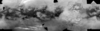
Product Information: The Cassini mission has returned an abundance of data about the surface of Titan. To maximize the science return from these data and to assist with planning for Cassini and…
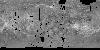
Product Information: This mosaic was created from the Magellan Full resolution Basic Image Data Records (F-BIDRs), the highest resolution radar images of the Venus surface (~75 meters per pixel…
Product Information: This synthetic colorized version of the C3-MIDR mosaic was developed to simulate the surface of Venus. This mosaic was created from the Magellan Full resolution Basic Image Data…
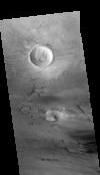
This PDS4 archive includes 1,354 HiRISE DEMs, 1,354 CTX DEMs that overlap the HiRISE DEMs, orthoimages associated with each, and pixel masks to show the quality of each stereo correlation. DEMs…
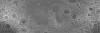
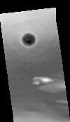
In 2019, NASA's OSIRIS-REx (Origins, Spectral Interpretation, Resource Identification, and Security – Regolith Explorer) mission globally surveyed asteroid (101955) Bennu with a collection of…
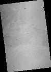
This orthorectified image was created by projecting an image from the Mars Reconnaissance Orbiter Context Camera (CTX) onto a Digital Terrain Model (DTM). The DTM is available under the “Derived…
This Digital Terrain Model (DTM) was produced as part of a project to understand Martian lava flows. It was constructed from a pair of Mars Reconnaissance Orbiter Context Camera (CTX) images using…