Products

139 Results Collapse
Moon LRO LOLA Color Shaded Relief 388m v4  thumbnail

Moon LRO LOLA Color Shaded Relief 388m v4

application/isis 3 GBAug 01 2011

Product Information: This is a colorized shaded-relief of a original polar digital elevation model (DEM) from the Lunar Orbiter Laser Altimeter (LOLA; Smith et al., 2010), an instrument on the…

Lunar LRO NAC Haworth Photoclinometry DEM 1m v3 thumbnail

Lunar LRO NAC Haworth Photoclinometry DEM 1m v3

image/tiff 1 kBJan 15 2021

This is a shape-from-shading (SfS or photoclinometry) digital elevation model (DEM) for the Haworth area. The Haworth area is beyond the north rim of Haworth crater and centered at 338.0 (-21.0) E,…

Mercury MESSENGER MDIS DEM Global Color Shaded Relief 2km v1 thumbnail

Mercury MESSENGER MDIS DEM Global Color Shaded Relief 2km v1

application/isis 84 MBMay 06 2016

Product Information: This is a colorized shaded-relief of the original digital elevation model (DEM). Using the Integrated Software for Imagers and Spectrometers (ISIS3) and observations from…

Mercury Shaded Relief Map of the Borealis Area thumbnail

Mercury Shaded Relief Map of the Borealis Area

application/pdf 3 MBOct 16 1977

Mars MGS MOLA - MEX HRSC Blended Shaded Relief 200m v2 thumbnail

Mars MGS MOLA - MEX HRSC Blended Shaded Relief 200m v2

application/octet-stream 1 kB

This is a shaded relief of the original DEM described next. This data product, now at version 2, is a blend of digital elevation model (DEM) data derived from the Mars Orbiter Laser Altimeter (MOLA),…

Project Pages

1 Result Collapse
Moon Control Networks thumbnail

Moon Control Networks

http://astrogeology.usgs.gov/maps/control-networks/moon

Lunar Orbiter Lunar Control Network 2004 
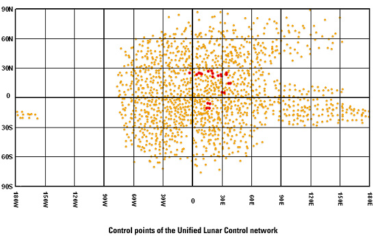
The USGS worked to digitize and restore a global set of Lunar Orbiter images and to assemble this into a global digital Lunar Orbiter mosaic of the Moon. A…