Products

180 Results Collapse
Tool Working Group thumbnail

Tool Working Group

application/vnd.openxmlformats-officedocument.presentationml.presentation 190 kB

PDS4 Change Control Board Status report thumbnail

PDS4 Change Control Board Status report

application/vnd.openxmlformats-officedocument.presentationml.presentation 47 kB

State of the IPDA 2018 thumbnail

State of the IPDA 2018

application/vnd.openxmlformats-officedocument.presentationml.presentation 11 MB

Imaging Node Status, Mar10 thumbnail

Imaging Node Status, Mar10

application/vnd.openxmlformats-officedocument.presentationml.presentation 1 MB

GIS Data in PDS4 thumbnail

GIS Data in PDS4

application/vnd.openxmlformats-officedocument.presentationml.presentation 2 MB

PDS4 Training Course thumbnail

PDS4 Training Course

application/vnd.openxmlformats-officedocument.presentationml.presentation 200 kB

Imaging Node Status, Mar10 thumbnail

Imaging Node Status, Mar10

application/vnd.openxmlformats-officedocument.presentationml.presentation 214 kB

Web Site Expressions of the PDS Focus thumbnail

Web Site Expressions of the PDS Focus

application/vnd.openxmlformats-officedocument.presentationml.presentation 8 MB

No Slide Title thumbnail

No Slide Title

application/vnd.ms-powerpoint 220 kB

PDS 2018 Tool Working Group Report thumbnail

PDS 2018 Tool Working Group Report

application/vnd.openxmlformats-officedocument.presentationml.presentation 1 MB

Project Pages

2 Results Collapse

Documents

180 Results Collapse
Moon LRO South Pole DEM from Narrow Angle Camera thumbnail

Moon LRO South Pole DEM from Narrow Angle Camera

application/pdf 310 kB

The Lunar Reconnaissance Orbiter Camera (LROC) consists of one Wide Angle Camera (WAC) for synoptic multispectral imaging and two Narrow Angle Cameras (NAC) that provide high-resolution images (0.5…

Initial Global Control Network and Moasicking of ISS Images of Titan thumbnail

Initial Global Control Network and Moasicking of ISS Images of Titan

application/pdf 450 kB

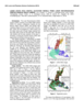
The Cassini mission has returned an abundance of data about the surface of Titan. To maximize the science return from these data and to assist with planning for Cassini and future missions, we have…

File Format Description thumbnail

File Format Description

application/pdf 14 kB

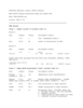
RAND/USGS Planetary Geodesy (RUPG) Software ISIS QMATCH Program Measurement Input and Output File

Suggestions for Randlsq Program Parameter Naming thumbnail

Suggestions for Randlsq Program Parameter Naming

application/pdf 17 kB

Stuart has suggested that I draft some suggestions for the format and names to be used for parameters in the randlsq.F program. I previously implemented the limited naming of parameters in this…

Modeling and Adjustment of THEMIS IR Line Scanner Camera Image Measurements thumbnail

Modeling and Adjustment of THEMIS IR Line Scanner Camera Image Measurements

application/pdf 269 kB

The overall problem we’re solving is that we want to be able to set up the relationships between the coordinates of arbitrary physical points in space (e.g. ground points) and their coordinates on…

Zebker et al. Size and Shape of Saturn's Moon Titan thumbnail

Zebker et al. Size and Shape of Saturn's Moon Titan

application/pdf 1 MB

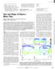
Cassini observations show that Saturn’s moon Titan is slightly oblate. A fourth-order spherical harmonic expansion yields north polar, south polar, and mean equatorial radii of 2574.32 T 0.05…

Lorenz et al. 2013 Titan Topographic Map of Titan thumbnail

Lorenz et al. 2013 Titan Topographic Map of Titan

application/pdf 7 MB

Cassini RADAR SARtopo and altimetry data are used to construct a global gridded 1 x 1° elevation map, for use in Global Circulation Models, hydrological models and correlative studies. The data are…

USGS Astrogeology 50th Anniversary Flyer thumbnail

USGS Astrogeology 50th Anniversary Flyer

application/pdf 667 kB

The USGS Astrogeology Science Center Honoring 50 Years of Public Service: Exploring the Solar System from Flagstaff, AZ

ISPRS 1998 Preliminary Mapping from the Mars Orbiter Laser Altimeter thumbnail

ISPRS 1998 Preliminary Mapping from the Mars Orbiter Laser Altimeter

application/pdf 59 kB

Since arrival at Mars in Sept. 1997 the Mars Orbiter Laser Altimeter (MOLA) on the Mars Global Surveyor (MGS) spacecraft has obtained a number of topographic profiles across the northern hemisphere…

ISPRS 1998 Mapping Mars using Virtual Reality: the Pathfinder Experience thumbnail

ISPRS 1998 Mapping Mars using Virtual Reality: the Pathfinder Experience

application/pdf 79 kB

The Pathfinder mission made use of a unique capability to rapidly generate and interactively display three-dimensional photo-realistic virtual reality (VR) models of the Martian surface. The Stereo…