Product Information: This digital elevation model (DEM) is based on data from the Mars Orbiter Laser Altimeter (MOLA; Smith et al., 2001), an instrument on NASA’s Mars Global Surveyor (MGS)…
This is a shape-from-shading (SfS or photoclinometry) digital elevation model (DEM) for the Haworth area. The Haworth area is beyond the north rim of Haworth crater and centered at 338.0 (-21.0) E,…
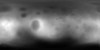
Product Information: This is a digital elevation model (DEM/DTM) of the Apollo 17 landing site generated from stereo images provided by the Lunar Reconnaissance Orbiter Camera (LROC) Narrow Angle…
Product Information: Using the Integrated Software for Imagers and Spectrometers (ISIS3) and observations from Mercury Dual Imaging System (MDIS) narrow-angle camera (NAC) and multispectral…
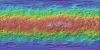
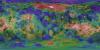
This is a colorized shaded-relief of the original Ceres digital terrain model (DTM). This DTM was created from the Dawn High Altitude Mapping orbit (HAMO) Framing Camera 2 (FC2) images and derived by…
Product Information: This digital terrain model (DTM) of Ceres based on the Dawn High Altitude Mapping Orbit (HAMO) Framing Camera 2 (FC2) images and derived by using the stereo photogrammetry (SPG)…
Product Information: This is a colorized shaded-relief of the original digital elevation model (DEM). Using the Integrated Software for Imagers and Spectrometers (ISIS3) and observations from…
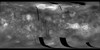
Product Information: Images from the European Space Agency's High Resolution Stereo Camera (HRSC) aboard the Mars Express were used to obtain 3-dimensional coordinates of surface points of Phobos.…
Product Information: The represents the version 2 (1997 release) of the Global Topographic Data Record (GTDR-SINUS.3;2). The range to surface is derived by fitting altimeter echoes from the fan-beam…
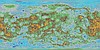
Product Information: This mosaic was created from the Magellan Full resolution Basic Image Data Records (F-BIDRs), the highest resolution radar images of the Venus surface (~75 meters per pixel…