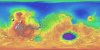
Product Information: This map is based on data from the Mars Orbiter Laser Altimeter (MOLA) (Smith, et al., 2001), an instrument on NASA’s Mars Global Surveyor (MGS) spacecraft (Albee, et al.,…
Product Information: This product represents a near-global lunar topography from stereo image data acquired by the Wide-angle Camera (WAC) of the Lunar Reconnaissance Orbiter Camera (LROC) system…
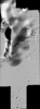
This is a grayscale hillshade of the original Ceres digital terrain model (DTM). This DTM was created from the Dawn High Altitude Mapping orbit (HAMO) Framing Camera 2 (FC2) images and derived by…
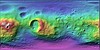
Product Information: This is a colorized shaded-relief of the original stereo-derived High Altitude Mapping Orbit (HAMO) digital terrain model (DTM). DAWN orbited Vesta during HAMO in 21 cycles…
Product Information: This is a shaded-relief of a original polar digital elevation model (DEM) from the Lunar Orbiter Laser Altimeter (LOLA; Smith et al., 2010), an instrument on the National…
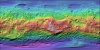
This is a colorized shaded-relief of the digital elevation model (DEM) extracted from the Lunar Reconnaissance Orbiter Camera (LROC) Narrow Angle Camera (NAC) stereo images from the Lunar…
This is a shaded-relief of the digital elevation model (DEM) extracted from the Lunar Reconnaissance Orbiter Camera (LROC) Narrow Angle Camera (NAC) stereo images from the Lunar Reconnaissance…
Product Information: This is a colorized shaded-relief of the original High Resolution Stereo Camera (HRSC) Digital Elevation Model (DEM) with a resolution of 100 meters per pixel (m). HRSC images…
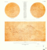
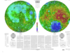
This publication is a set of three sheets of topographic maps that presents color-coded topographic data digitally merged with shaded relief data. Adopted figure: The figure for the Moon, used for…