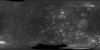
This global map of Callisto utilizes the best image quality and moderate resolution coverage supplied by Galileo SSI (Solid State Imaging instrument) and Voyager 1 and 2. This mosaic was prepared…
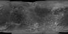
Product Information: This global mosaic of Ganymede utilizes the best image quality and moderate resolution coverage supplied by Galileo Solid-State Imaging (SSI) and Voyager 1 and 2. The image data…
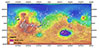
This product is a cartographically controlled mosaic of Mars Charts (MC) 08 through 23, covering 50.0 percent of Mars' surface, from -30 deg N to +30 deg N latitude and 0–360 deg E longitude. The…
he Near Earth Asteroid Rendezvous – Shoemaker (NEAR; Cheng et al., 1997) spacecraft orbited and studied the surface of asteroid (433) Eros for a year from 14 February 2000 to 12 February 2001. Eros…
This PDS4 archive includes 1,354 HiRISE DEMs, 1,354 CTX DEMs that overlap the HiRISE DEMs, orthoimages associated with each, and pixel masks to show the quality of each stereo correlation. DEMs…
This is a shape-from-shading (SfS or photoclinometry) digital elevation model (DEM) for the Haworth area. The Haworth area is beyond the north rim of Haworth crater and centered at 338.0 (-21.0) E,…
This 3D point cloud describes the global shape of Saturn’s moon Enceladus. The model is both near-global in extent and relatively high "resolution", and is intended to support scientific…
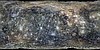
Product Information: This is an orthomosaic of the Apollo 17 landing site created from images provided by the Lunar Reconnaissance Orbiter (LRO) Camera (LROC) Narrow Angle Camera (NAC). The images…
This mosaic shows Mercury's colors as viewed by placing images from MESSENGER's 1000 nm, 750 nm, and 430 nm narrow-band filters in the red, green, and blue channel respectively. This is not what…