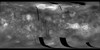
Product Information: Using the Integrated Software for Imagers and Spectrometers (ISIS3) and observations from Mercury Dual Imaging System (MDIS) narrow-angle camera (NAC) and multispectral…
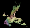
This is a colorized shaded-relief of the original Ceres digital terrain model (DTM). This DTM was created from the Dawn High Altitude Mapping orbit (HAMO) Framing Camera 2 (FC2) images and derived by…
Product Information: This digital terrain model (DTM) of Ceres based on the Dawn High Altitude Mapping Orbit (HAMO) Framing Camera 2 (FC2) images and derived by using the stereo photogrammetry (SPG)…
Product Information: This product represents a near-global lunar topography from stereo image data acquired by the Wide-angle Camera (WAC) of the Lunar Reconnaissance Orbiter Camera (LROC) system…
Product Information: Images from the European Space Agency's High Resolution Stereo Camera (HRSC) aboard the Mars Express were used to obtain 3-dimensional coordinates of surface points of Phobos.…
Product Information: The represents the version 2 (1997 release) of the Global Topographic Data Record (GTDR-SINUS.3;2). The range to surface is derived by fitting altimeter echoes from the fan-beam…
The Lunar Reconnaissance Orbiter Camera (LROC) consists of one Wide Angle Camera (WAC) for synoptic multispectral imaging and two Narrow Angle Cameras (NAC) that provide high-resolution images (0.5…
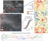
This archive contains topography and photometric data generated by the Gaskell Stereophotoclinometry (SPC) software suite. It focuses on six regions on the Moon. These include wrinkle ridges at Dorsa…
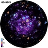
The Ice Favorability Index (IFI) maps below are based on a geologic system model for ice deposition and evolution (Cannon and Britt 2020). The index maps are predictive, not based on surface ice…