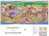
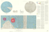
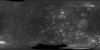
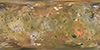
Geologic Map of Io, SIM 3168
application/zip 268 MBMar 13 2012Io, discovered by Galileo Galilei on January 7-13, 1610, is the innermost of the four Galilean satellites of the planet Jupiter. It is the most volcanically active object in the Solar System, as…