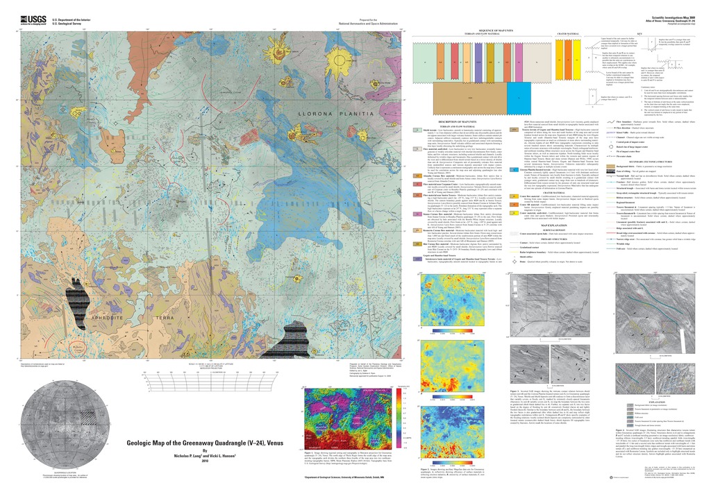
Venus Geologic Map of the Greenaway Quadrangle (V-24)
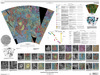
The Greenaway quadrangle (V-24; lat 0 degrees -25 degrees N., long 120 degrees -150 degrees E.), Venus, derives its name from the impact crater Greenaway, centered at lat 22.9 degrees N., long 145.1 degrees E., in the northeastern part of the quadrangle. Greenaway was a well-noted writer and illustrator of children`s books in Britain during the nineteenth century. In Greenaway`s honor, the Library Association of Great Britain presents the annual Kate Greenaway Medal to an illustrator living and publishing in Britain who has produced the most distinguished children`s book illustrations for that year. The Greenaway quadrangle occupies an 8,400,000 km2 equatorial swath of lowlands and highlands. The map area is bounded by the crustal plateau, Thetis Regio, to the south and Gegute Tessera to the west. The rest of the quadrangle consists of part of Llorona Planitia, which is part of the vast lowlands that cover about 80 percent of Venus` surface. The southern map area marks the north edge of Aphrodite Terra, including Thetis Regio, that includes the highest topography in the quadrangle with elevations reaching >1 km above the Mean Planetary Radius (MPR; 6,051.84 km). Northern Aphrodite Terra abruptly slopes north to Llorona Planitia. A broad northeast-trending topographic arch pocked with coronae separates two northeast-trending elongate basins, Llorona Planitia on the east, that form depositional centers for shield and coronae-sourced materials; both basins drop to elevations of
- Mimetype
- application/pdf
- Filename
- Venus-Geologic-Map-of-the-Greenaway-Quadrangle-V-24.pdf
- Publisher
- USGS Astrogeology Science Center
- Publication Date
- 10 February 2010
- Author
- Nicholas P. Lang and Vicki L. Hansen
- Originator
- N. Lang, V. Hansen
- Group
- RPIF
- Added to Astropedia
- 21 April 2016
- Modified
- 31 October 2017
General
- Geospatial Data Presentation Form
- Geologic Map, Raster Data, Vector Data
- Series Id
- 3089
Keywords
- Target
- Venus
- Theme
- Cartography, Geology, Geomorphology, Photogeology, Stratigraphy, Planetary evolution
- Mission
Contact and Distribution
- Access Instructions
- Pamphlet: ii, 14 p.; Table; 1 Map Sheet: 44.84 x 31.20 inches
Geospatial Information
- Minimum Latitude
- 0
- Maximum Latitude
- 25
- Minimum Longitude
- 120
- Maximum Longitude
- 150
- Quad Name
- V-24