
Phobos Crater Catalog v1 Salamunićcar
In a large majority of lunar and planetary surface images, impact craters are the most abundant geological features. Therefore, it is not surprising that crater detection algorithms (CDAs) are one of the most studied subjects of image processing and analysis in lunar and planetary science.
We developed an Integrated CDA, consisting of: (1) utilization of DEM (digital elevation map) -based CDA; (2) utilization of an optical-based CDA; (3) re-projection of used datasets and crater coordinates from normal to rotated view and back; (4) correction of the brightness and contrast of a used optical image; and (5) tile generation for the optical-based CDA and an assembling of results with an elimination of multiple detections, in combination with a pyramid approach down to the resolution of the available DEM image; and (6) a final integration of the results of DEM-based and optical-based CDAs, including a removal of duplicates.
The proposed CDA is applied to one specific asteroid-like body, the small Martian moon Phobos. The experimental evaluation of the proposed CDA is done by a manual verification of crater-candidates and a search for uncatalogued craters. The evaluation has shown that the proposed CDA was used successfully for cataloging Phobos craters.
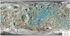
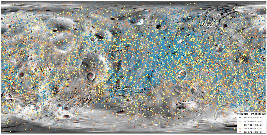
The major result is the PH9224GT – currently the most complete global catalogue of the 9224 Phobos craters. The possible applications of the new catalogue are: (1) age estimations for any selected location; and (2) comparison/evaluation of the different chronology and production functions for Phobos.
Reference:
Salamunićcar, G., Lončarić, S., Pina, P., Bandeira, L., & Saraiva, J. (2013). Integrated method for crater detection from topography and optical images and the new PH9224GT catalogue of Phobos impact craters. Advances in Space Research, 53(12), 1798-1809. https://doi.org/10.1016/j.asr.2013.11.006
Stooke. P., Stooke Small Bodies Maps V3.0. MULTI-SA-MULTI-6-STOOKEMAPS-V3.0. NASA Planetary Data System, 2015. https://sbn.psi.edu/pds/resource/stookemaps.html
- Mimetype
- application/zip
- Filename
- GoranSalamuniccar_PhobosCraters.zip
- Publisher
- Goran Salamunićcar
- Author
- Goran Salamunićcar
- Originator
- Sven Lončarić, Pedro Pina, Lourenço Bandeira, José Saraiva
- Group
- PDS, MRCTR
- Added to Astropedia
- 2 January 2014
- Modified
- 3 February 2020
General
- Purpose
The catalogue can be used for evaluation of crater detection algorithms (CDAs) and other planetary science studies.
- Geospatial Data Presentation Form
- Vector Data
- Online Linkage
- http://astropedia.astrogeology.usgs.gov/download/Phobos/Research/Craters/GoranSalamuniccar_PhobosCraters.zip
- Native Data Set Environment
- ESRI Arcinfo
- Supplemental Information
- http://dx.doi.org/10.1016/j.asr.2013.11.006
Keywords
- System
- Mars
- Target
- Phobos
- Theme
- Craters, Impact Crater, Geographic Information System (GIS), Geology, Remote Sensing, Topography
- Search Terms
- Phobos, Crater, Automatic, Catalog, Catalogue
Contact and Distribution
- Access Constraints
- None
- Access Instructions
- GIS application needed for viewing files.
- Use Constraints
- Please cite authors
Data Status and Quality
- Time Period of Content Begin
- 31 December 2010
- Time Period of Content End
- 20 October 2012
- Currentness Reference
- Publication date
- Progress
- In Work
- Update Frequency
- As needed
- Logical Consistency Report
- Coordinates and diameters are consistent with all data sets used (topographic as well as optical).
- Completeness Report
This catalogue is complete up to ∼D≥50 m
- Process Description
In short, craters from all previous manually created catalogues and numerous additional craters detected using CDAs have been integrated into the single catalogue. In details, it is described in [1].
- Horizontal Positional Accuracy Value
- 50
- Horizontal Positional Accuracy Report
- Unknown
- Vertical Positional Accuracy Value
- 0
- Vertical Positional Accuracy Report
- Best Effort
- Entity and Attribute Overview
- Latitude, Longitude, Radius
- Entity and Attribute Detailed Description
- Latitude in planetocentric, Longitude in positive East, Radius in kilometers, meters, and degrees.
Lineage
- PDS Status
- PDS 4 In Progress
- Source Originator
- Stooke and DLR
- Source Publication Date
- 15 March 2012
- Source Title
- Stooke. P., Stooke Small Bodies Maps V2.0. MULTI-SA-MULTI-6-STOOKEMAPS-V2.0. NASA Planetary Data System, 2012.
- Source Online Linkage
- http://sbn.psi.edu/pds/resource/stookemaps.html
- Type of Source Media
- Online
- Attribute Accuracy Report
- Best Effort
Geospatial Information
- Location Description
- Global
- Minimum Latitude
- -90
- Maximum Latitude
- 90
- Minimum Longitude
- -180
- Maximum Longitude
- 180
- Direct Spatial Reference Method
- Vector
- Object Type
- Point
- Quad Name
- Radius A
- 11100
- Radius C
- 11100
- Control Net
- HRSC
- Scale (pixels/degree)
- 16
- Map Projection Name
- Simple Cylindrical
- Latitude Type
- Planetocentric
- Longitude Direction
- Positive East
- Longitude Domain
- -180 to 180


