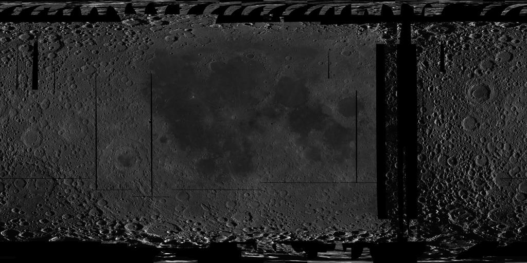
Moon SELENE Kaguya TC Morning Global Mosaic 474m v4
Product Information:
This near-global mosaic was generated using data from the SELenological and Engineering Explorer (SELENE) “Kaguya” Terrain Camera (TC) instrument. TC source data originated as map-projected tiles at ~10 meters per pixel (m) spatial resolution.
Mission and Instrument Information:
The Japan Aerospace Exploration Agency (JAXA) launched the SELENE/Kaguya spacecraft to the Moon in September 2007. The mission concluded June 10, 2009 when the spacecraft was intentionally crashed onto the lunar surface. Subsequent data collection and mapping efforts resulted in “the largest lunar exploration project since the Apollo program” (Haruyama et al., 2008). The high-performance optical TC, a 10-meter spatial resolution stereo-camera, was part of the Lunar Imager/Spectrometer (LISM) instrument suite (Kato et al., 2006), along with the Multi-band Imager (MI, 20 m; Ohtake et al., 2008)) and Spectral Profiler (SP; Matsunaga et al., 2008).
Mission objectives for the TC included production of global, high-resolution, high-contrast mosaicked maps (tiles) of the Moon (e.g., Kato et al., 2006; Haruyama et al., 2008). The SELENE team released map-projected near-global coverage of TC data with both Morning (“Morn”) and Evening (“Eve”) illuminations (low-sun, early or right-to-left low-angle solar illumination, and late or left-to-right solar illumination). The 3x3-degree tiles (7200 nominal count per set) are spatially co-registered to the Kaguya global DTM and match very well with the positions of the Apollo Lunar Retroreflector array (-17 to 5 m longitude, -20 to 48 m latitude, 3 to 5 m elevation; Haruyama et al., 2012). With the quality of registration, high spatial resolution, and image clarity, these data provide excellent complements to color data such as those from the LRO Wide Angle Camera and the Clementine UVVIS for geologic studies, mapping, and morphologic and structural analyses of the lunar surface.
For use, refer to the JAXA Conditions for material usage page ( http://jda.jaxa.jp/en/service.php ) and please credit JAXA and the SELENE/Kaguya data. ©JAXA/SELENE
References:
Haruyama, J., Hara, S., Kioki, K., Iwasaki, A., Morota, T., Ohtake, M., Matsunaga, T., et al. (2012). Lunar global digital terrain model dataset produced from SELENE (Kaguya) Terrain Camera stereo observations. Paper presented at the 43rd Lunar and Planetary Science Conference, Lunar and Planetary Institute, Houston, TX. https://www.lpi.usra.edu/meetings/lpsc2012/pdf/1200.pdf
Haruyama, J., Matsunaga, T., Ohtake, M., Morota, T., Honda, C., Yokota, Y., Torii, M., Ogawa, Y., & LISM Working Group (2008). Global lunar-surface mapping experiment using the Lunar Imager/Spectrometer on SELENE. Earth Planets Space, 60, 243-255. https://doi.org/10.1186/BF03352788
Kato, M., Takizawa, Y., Sasaki, S., & SELENE Project Team (2006). SELENE, The Japanese lunar orbiting satellites mission: Present status and science goals. Paper presented at the 37th Lunar and Planetary Science Conference, Lunar and Planetary Institute, Houston, TX. https://www.lpi.usra.edu/meetings/lpsc2006/pdf/1233.pdf
Kato, M., Takizawa, Y., & Sasaki, S., & SELENE Project Team (2007). The SELENE Mission: Present status and science goals. Paper presented at the 38th Lunar and Planetary Science Conference, Lunar and Planetary Institute, Houston, TX. https://www.lpi.usra.edu/meetings/lpsc2007/pdf/1211.pdf
Matsunaga, T., Ohtake, M., Haruyama, J., Ogawa, Y., Nakamura, R., Yokota, Y., Morota, T., et al. (2008). Discoveries on the lithology of lunar crater central peaks by SELENE Spectral Profiler. Geophysical Research Letters, 35(23). https://doi.org/10.1029/2008GL035868
Ohtake, M., Haruyama, J., Matsunaga, T., Yokota, Y., Morota, T., Honda, C., & LISM Team (2008). Performance and scientific objectives of the SELENE (KAGUYA) Multiband Imager. Earth Planets Space, 60, 257-264. https://doi.org/10.1186/BF03352789
- Publisher
- USGS Astrogeology Science Center
- Author
- JAXA - SELENE TC Instrument Team
- Originator
- USGS Astrogeology Science Center
- Group
- PDS
- Added to Astropedia
- 4 March 2014
- Modified
- 5 March 2020
General
- Purpose
One of the primary goals for the Kaguya mission was to augment the high-resolution image data available for the lunar surface, particularly the far side. At 10 m/pixel globally, the TC data effectively bridge the resolution gap between the LROC WAC (100 m/pixel) and the LROC NAC (~1 m/pixel) data and thus they provide invaluable contextual information. The data have enabled discoveries of relatively small lunar features such as lava-tube skylights, small impact craters used to determine relative age, lack of exposed ice at Shackleton crater (lunar south pole) and mare eruption ages. Availability of the global TC data will greatly facilitate a wide variety of lunar studies, including relative and absolute chronology (e.g., crater counting), geologic mapping, structural analyses, site characterization, etc. to better understand the Moon’s geologic record. The low-sun and dual-illumination TC data provide unmatched morphologic information that support geologic and feature mapping at local to regional scales (~1:50, 000 to ~1:250, 000). The availability of coverage at multiple illuminations will help to ensure that any given site can be studied.
- Geospatial Data Presentation Form
- Raster Data, Global Mosaic, Image, Grey Scale
- Online Linkage
- https://planetarymaps.usgs.gov/mosaic/Lunar_Kaguya_TC_Morning_Global_64ppd_v04.tif
- Native Data Set Environment
- ISIS v3
- Color
- Black and White
- Supplemental Information
- http://jda.jaxa.jp/en/service.php, https://www.sciencedirect.com/science/article/pii/S0019103513002108, https://pds-imaging.jpl.nasa.gov/documentation/PDS_KaguyaData_Jan.31.11.pdf, https://pds-imaging.jpl.nasa.gov/portal/kaguya_mission.html, https://pds-imaging.jpl.nasa.gov/documentation/LISM-SPICE_Format_en_V01.3.pdf
Keywords
- System
- Earth
- Target
- Moon
- Theme
- Geomorphology, Geophysical, Remote Sensing, Image Processing
- Mission
- Kaguya
- Instrument
- TC
Contact and Distribution
- Access Instructions
- Full resolution segments (4096pxl/deg) available here: Latitude range is ±90 with filename indicating longitude range for each segment. (Population in progress) pdsimage.wr.usgs.gov/downloads/Kaguya_TC/
Data Status and Quality
- Time Period of Content Begin
- 19 October 2007
- Time Period of Content End
- 31 October 2008
- Currentness Reference
- Publication date
- Progress
- Complete
- Update Frequency
- None planned
- Logical Consistency Report
- The TC Morning source products were released in 2010, with positional information based on lunar gravity field model and orbital parameters determined prior to January 2010. They may retain small errors (less than 10 pixels) in registration as well as gaps, missing pixels, and null values in the tiles. These issues appear to affect <10% of the TC data.
- Completeness Report
This TC Morning version 4 mosaic consists of 7, 200 tiles (of nominal 7, 200) as released by the Kaguya Team.
- Process Description
Source data were downloaded from the SELENE-Kaguya TC on-line data repository. Source product “PDS-like” image labels contained primary information with the need for specific corrections to be applied in preparation for ISIS ingestion and mosaic assembly. These corrections included target value updates, map scale value updates, map projection offset adjustment, and special pixel value assignment. Corrected products were then ingested within ISIS via the ‘kaguyatc2isis’ application. Mosaics were assembled via the ‘mapmos’ ISIS application. OS shell and Perl scripting were utilized within the entire download, processing, and mosaicking procedures. Storage and processing cluster infrastructure were utilized.
- Horizontal Positional Accuracy Value
- 100
- Horizontal Positional Accuracy Report
- Best Effort
Lineage
- PDS Status
- PDS 3 Like
- Source Originator
- Japan Aerospace Exploration Agency (JAXA)
- Source Online Linkage
- http://darts.isas.jaxa.jp/planet/pdap/selene/index.html.en, http://www.kaguya.jaxa.jp/index_e.htm
- Type of Source Media
- Online
Geospatial Information
- Minimum Latitude
- -90
- Maximum Latitude
- 90
- Minimum Longitude
- -180
- Maximum Longitude
- 180
- Direct Spatial Reference Method
- Raster
- Object Type
- Pixel
- Lines (pixels)
- 11520
- Samples (pixels)
- 23040
- Bit Type
- 16
- Quad Name
- Radius A
- 1737400
- Radius C
- 1737400
- Bands
- 1
- Pixel Resolution (meters/pixel)
- 473.80235037734
- Scale (pixels/degree)
- 64
- Horizontal Coordinate System Units
- Meters
- Map Projection Name
- Simple Cylindrical
- Latitude Type
- Planetocentric
- Longitude Direction
- Positive East
- Longitude Domain
- 0 to 360