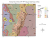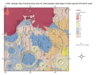
Mars 15M Geologic Map GIS Renovation
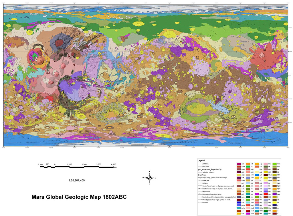
A digital adaptation of the hard-copy Viking Orbiter-based geologic maps of Mars. The western equatorial region was originally mapped by David H. Scott and K. L. Tanaka (USGS I-1802-A, 1986, 1:15M scale). The eastern equatorial region was originally mapped by Ronald Greeley and J. E. Guest (USGS I-1802-B, 1987, 1:15M scale). The north and south polar regions were originally mapped by K. L. Tanaka and D. H. Scott (USGS I-1802-C, 1987, 1:15M scale). A conference abstract submitted to the 37th Lunar and Planetary Science Conference outlines and discusses the rationale and methodology for the digitized version presented herein. The abstract reference is: Skinner, J. A., Jr, T. M. Hare, and K. L. Tanaka 2006, LPSC XXXVII, abstract #2331.
- Mimetype
- application/zip
- Filename
- Mars15MGeologicGISRenovation.zip
- Publisher
- USGS Astrogeology Science Center
- Publication Date
- 1 March 2006
- Author
- James A. Skinner, Jr.
- Originator
- Trent Hare, Ken Tanaka
- Group
- MRCTR
- Added to Astropedia
- 2 August 2013
- Modified
- 3 June 2019
General
- Purpose
The digital product presented herein is an adaptation. In support of ongoing scientific analysis and in advance of renewed global geologic mapping efforts, we have digitized the Viking-based Atlas of Mars, 1:15, 000, 000 Geologic Series (AMG) maps (USGS I-1802A-C) originally published in 1986 and 1987.
- Geospatial Data Presentation Form
- Geologic Map, Vector Data
- Edition
- 1
- Native Data Set Environment
- ESRI Arcinfo
- Supplemental Information
- http://www.lpi.usra.edu/meetings/lpsc2006/pdf/2331.pdf
Keywords
- System
- Mars
- Target
- Mars
- Theme
- Geographic Information System (GIS), Geology
- Mission
- Viking Orbiter
- Mission Specific
Contact and Distribution
- Access Constraints
- None
- Access Instructions
- You will need GIS software to view
- Use Constraints
- None
Data Status and Quality
- Currentness Reference
- Publication date
- Progress
- Complete
- Update Frequency
- None planned
- Logical Consistency Report
- These data are believed to be logically consistent. Line geometry is topologically clean.
- Completeness Report
The digital lines were drawn at approximately 1:2M scale with a node spacing of approximately 1 km. This digitized linework was intersected and cleaned by hand, using both smoothing algorithms (tolerance = 20 km) and generalizing algorithms (tolerance = 0.250 km). These efforts attempted to balance digital information, accuracy, and map aesthetics.
- Process Date
- 1 March 2006
- Process Description
The final digital product presented herein was adapted from the scanned linework of the original I-1802 maps. These original scans used outdated Martian geodesy, resulting in inaccurately placed contacts and structures. For the digital product presented herein, we used Viking Orbiter digital image mosaics and the Mars Orbiter Laser Altimeter (MOLA) dataset [Smith et al. 2001] as basemaps to correctly align geologic contacts and structural symbols by hand in ArcGIS.
- Horizontal Positional Accuracy Value
- 1000
- Horizontal Positional Accuracy Report
- Accurate to Control Net
- Entity and Attribute Overview
- Fields are available in the GIS files which define the geologic units. See included metadata for unit descriptions.
- Entity and Attribute Detailed Description
- See included metadata for unit descriptions.
Lineage
- Source Originator
- I-1802 Geologic Maps, U. S. Geological Survey
- Source Publication Date
- 1 January 2017
- Source Title
- USGS I-1802 A-C Mars Geologic Maps
- Type of Source Media
- Stable-Base Material
- Attribute Accuracy Report
- Accurate to Control Net
Geospatial Information
- Location Description
- Global
- Minimum Latitude
- -90
- Maximum Latitude
- 90
- Minimum Longitude
- -180
- Maximum Longitude
- 180
- Direct Spatial Reference Method
- Vector
- Object Type
- Polygon
- Quad Name
- Radius A
- 3396190
- Radius C
- 3396190
- Control Net
- MOLA
- Horizontal Coordinate System Units
- Degrees
- Map Projection Name
- Simple Cylindrical
- Latitude Type
- Planetocentric
- Longitude Direction
- Positive East
- Longitude Domain
- -180 to 180