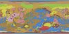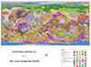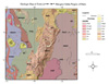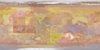
Mars Viking Geologic Map I-2107 of North Kasei Valles
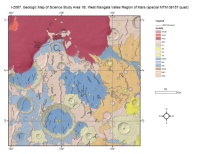
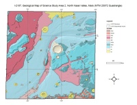
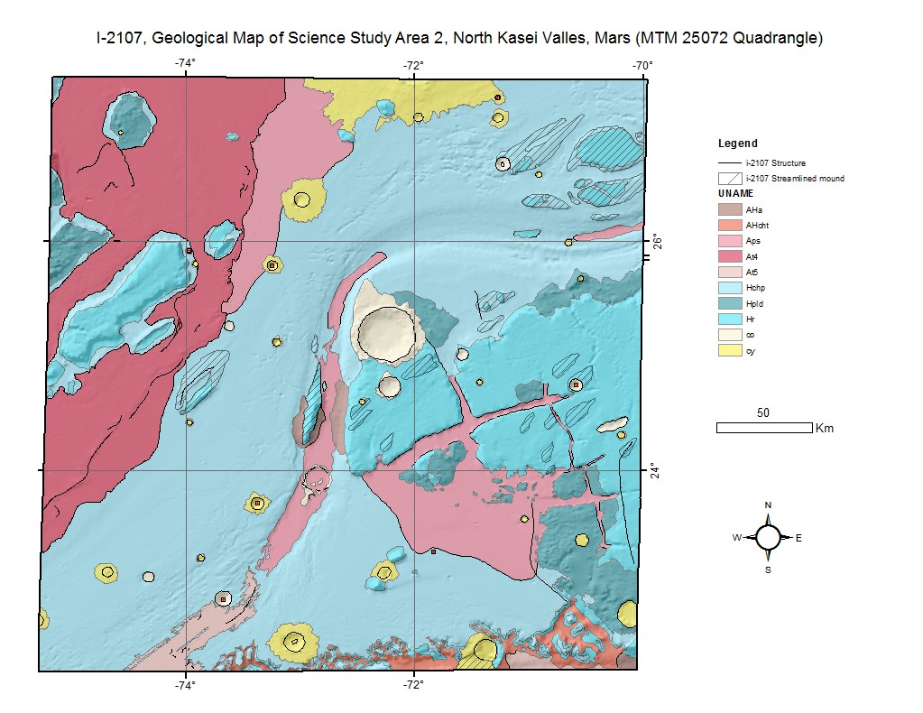
The north Kasei Valles area merits detailed geologic study because it contains part of a large channel system whose age can be determined relative to geologic units that range in age from the early intermediate (Early Hesperian) to the very late (Late Amazonian) periods of Martian history. Also, many geomorphic features in the map area suggest changes in water level and multiple erosional events associated with the Kasei Valles system. Later erosional events are indicative of spring sapping; small-scale, ground-water runoff; and water-mobilizing debris flow. Therefore, this large-scale mapping has increased our understanding of the history of hydrologic processes of Mars (Chapman and Scott, 1989). For these reasons, part of the area is a candidate site for a sample-return mission to the planet.
- Mimetype
- application/zip
- Filename
- Mars-Viking-Geologic-Map-I-2107-of-North-Kasei-Valles.zip
- Publisher
- USGS Astrogeology Science Center
- Publication Date
- 1 January 2023
- Author
- Chapman, Mary
- Originator
- USGS Astrogeology Science Center, Masursky, Harold, Scott, David H.
- Group
- MRCTR
- Added to Astropedia
- 2 December 2013
- Modified
- 16 June 2021
General
- Purpose
Mars geologic mapping
- Geospatial Data Presentation Form
- Geologic Map, Vector Data, Raster Data
- Series Id
- I-2107
- Edition
- 1
- Online Linkage
- http://astrogeology.usgs.gov/search
- Native Data Set Environment
- ESRI Arcinfo
- Color
- Color
Keywords
- System
- Mars
- Target
- Mars
- Theme
- Geology, Geographic Information System (GIS), Geomorphology, Canyons, Water
- Mission
- Viking
- Mission Specific
- Instrument
- VISA, VISB
- Search Terms
- Mars, Geology, Kasei Valles
Contact and Distribution
- Access Constraints
- None
- Access Instructions
- You will need GIS software to view included files.
- Use Constraints
- None
Data Status and Quality
- Currentness Reference
- Publication date
- Progress
- Complete
- Update Frequency
- None planned
- Logical Consistency Report
- These data are believed to be logically consistent, though no tests were performed.
- Completeness Report
Maps were completed on Viking-era basemaps.
- Process Description
This map was compiled on a Viking 1:500, 000-scale photomosaic base (U.S. Geological Survey, 1984). Some maps units correspond or are partly equivalent to units on smaller scale maps (Milton, 1974; Scott and Tanaka, 1986), and the formal terminology of geologic units proposed by Scott and Tanaka (1986) was followed where feasible. However, in many places interpretations and contacts have been revised to reflect information visible on higher resolution images whose geomorphologic details were clarified by spatial filtering (Condit and Chavez, 1979). The depths of channels, thicknesses of geologic units, and heights of scarps were obtained in places by using photoclinometric methods of Davis and Soderblom (1984). The relative ages of geologic units and of various geomorphic features, such as ridges, depressions, channels, crevices forming rectilinear patterns, streamlined mounds, and grooves, were established by stratigraphic relations and supported by crater counts. The stratigraphic positions of erosional units represent the time of their modification relative to other material units whose positions in sequence reflects their time of emplacement. Erosional units may thus consist of older material that is in place but has been highly modified by later processes (Milton, 1974).
Map preparation was on mylar or acetate made from USGS negatives. All features were scanned at 50 microns and then vectorized and attributed in ArcGIS.
- Entity and Attribute Linkage
- http://astrogeology.usgs.gov/rpif
Lineage
- Source Originator
- USGS Astrogeology Science Center
- Source Title
- Geological Map of Science Study Area 2, North Kasei Valles, Mars (MTM 25072 Quadrangle)
- Source Online Linkage
- http://astrogeology.usgs.gov/search
- Type of Source Media
- Stable-Base Material
- Attribute Accuracy Report
- Best Effort
Geospatial Information
- Feature Name
- North Kasei Valles
- Feature Target
- North Kasei Valles
- Location Description
- Kasei Valles Region of Mars
- Minimum Latitude
- 22.4007
- Maximum Latitude
- 27.5995
- Minimum Longitude
- -75.0994
- Maximum Longitude
- -69.9007
- Direct Spatial Reference Method
- Vector
- Object Type
- Polygon
- Quad Name
- Control Net
- Viking MDIM1.0
- Map Projection Name
- Transverse Mercator
- Latitude Type
- Planetocentric
- Longitude Direction
- Positive East
- Longitude Domain
- -180 to 180